
What Time is It Here?
Finding out what time it is, is often as simple as looking at a clock. But when you need to know the time on another place on Earth, you also need to know in which timezone you are in. Timezones are a bit more complicated than the UTC-offset, or a timezone abbreviation (such as GMT or EST). In order to correctly identify a set of Daylight Saving Time rules (and other changes in UTC-offset) for a specific location you need to know its Timezone Identifier. These have the form of Europe/London or America/Indiana/Knox and any decent sysadm (and hopefully every developer!) will know what the Timezone Identifier for their specific area is. It becomes more difficult if you need to know the Timezone Identifier in a unfamiliar location, such as Indiana in the US, where there are eleven different identifiers.
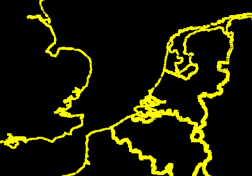
The `Olson Database`_ stores for each Identifier a region, but it does not record which geographical area is associated with that region. Eric Muller provides (ESRI) shape files containing that information through his website: http://efele.net/maps/tz/world/ . For each Timezone Identifier there are one or more polygons, where some polygons also have holes in them. In the case of Italy, that is to exclude San Marino and The Vatican for example but there are a few other examples as well. But we still need to go from a latitude/longitude pair to a Timezone Identifier.
Importing the Data
I already have written about importing OpenStreetMap data into MongoDB and I am going to use the same script to import the shape files into MongoDB. But we need to get to .osm files (which are XML) first. The quickest way I found to do this is by opening the shape file in JOSM. As it is a rather big file, this will take some time. I've just opened it by adding it as an argument on the command line:
wget http://efele.net/maps/tz/world/tz_world_mp.zip
unzip tz_world_mp.zip
josm world/tz_world_mp.shp
And you get an extract that looks something like this:
JOSM then allows us to save it as an OSM file that we subsequently can import with the MongoDB/OSM import script that I wrote about in importing OpenStreetMap data:
php import-data.php /tmp/tz-world.osm timezone
We use the extra argument timezone here to import it into a different MongoDB collection.
Over Land
To find out all the areas that uses the same timezone at a given location, we could use the follow data queries (as psuedo code):
-
Find the Timezone Identifier of the area that our current location points at.
-
Select all areas that have the same Timezone Identifier.
In the examples scripts, the center point's location is stored in the $center variable which is a GeoJSONPoint object. Its class is defined in https://raw.github.com/derickr/3angle/master/classes.php. My co-worker Jeremy Mikola has started on a GeoJSON library which I might start using instead of keeping my own (hacky) variant in the future.
var_dump'ing $center->getGeoJson() renders:
array(2) {
  'type' =>
  string(5) "Point"
  'coordinates' =>
  array(2) {
        [0] => double(5.3009033203125)
        [1] => double(53.388242750108)
  }
}
This is a GeoJSON structure that MongoDB's $geoIntersects operator uses. In this case, we try to find all documents in our collection that intersect with the center point, or in other words, find all the documents in the collection where the timezone polygon includes our center point.
The PHP script to do this, looks like:
<?php
include 'classes.php';

// defines and setup our center point variable
define( 'LOC', 'l' );
$center = new GeoJSONPoint( 5.3009033203125, 53.38824275010831 );

// connect and select database 'demo'
$m = new MongoClient;
$d = $m->demo;

// Select timezone collection
$tzc = $d->selectCollection( 'timezone' );

// Construct geo query for current center point.
$query = array(
        LOC => array(
                '$geoIntersects' => array(
                        '$geometry' => $center->getGeoJson(),
                ),
        ),
);

// this finds the first TZID
$s = $tzc->findOne( $query );

var_dump( $s );
?>
It's output (after formatting) is:
array(4) {
  '_id' => string(9) "w-1643005"
  'ty' => int(2)
  'l' => array(2) {
        'type' => string(7) "Polygon"
        'coordinates' => array(1) {
          [0] => array(76) {
                ...
          }
        }
  }
  'ts' => array(1) {
        [0] => string(21) "TZID=Europe/Amsterdam"
  }
}
If we represent that as an image, we'll see:
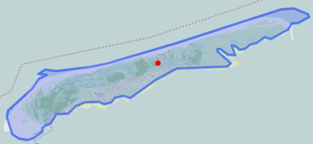
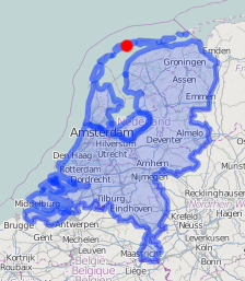
With the Timezone Identifier that we find ($s['ts']) we can now find all the other documents that have the same Timezone Identifier:
<?php
include 'classes.php';

// defines
define( 'TAGS', 'ts' );

// connect and select database 'demo' and
// collection 'timezone'
$m = new MongoClient;
$d = $m->demo;
$tzc = $d->selectCollection( 'timezone' );

$s = $tzc->find( array(
        TAGS => 'TZID=Europe/Amsterdam'
) );

foreach ( $s as $part )
{
        var_dump( $part );
}
?>
Territorial Waters
With the above two snippets we can now find the timezone, and hence the time, for the areas that cover land. However, the same timezone is valid inside the territorial waters that belong to that specific area. The territorial waters in general extend up to 22km off the coast. The downloaded shape files however don't cover the territorial waters and we hence need to find which shape, as contained in our documents in the MongoDB collection, is closest, but no further than 22km from our "center point". We could use $near for this, but instead I am using the Aggregation Framework to show that it is possible to calculate and return the distance as well.
A $near or $geoIntersects query always returns a full document, similar to normal queries in MongoDB, but with the Aggregation Framework you can also modify the returned documents. In our case, we use that to calculate the distance between our center point and the polygon that is stored in the documents in MongoDB and add this information to the result. Aggregation is done through a command, which in PHP is implemented as the aggregate() helper on the MongoCollection class. Commands don't return a cursor, but just one document containing some meta-information, and an array of results. See the article MongoDB's aggregation framework for an introduction into the Aggregation Framework. Let's have a look at how we use the $geoNear aggregation in PHP:
<?php
include 'classes.php';

// defines
define( 'TYPE', 'ty' );
$center = new GeoJSONPoint( 0.99, 50.097 );

// connect and select database 'demo' and collection 'timezone'
$m = new MongoClient;
$d = $m->demo;
$tzc = $d->selectCollection( 'timezone' );

// run the aggregation
$s = $tzc->aggregate(
        [ '$geoNear' => [
                'near' => $center->getGeoJSON(),
                'distanceField' => 'd',
                'distanceMultiplier' => 1,
                'maxDistance' => 22000,
                'spherical' => true,
                'query' => [
                        TYPE => [ '$gte' => 2 ],
                ],
                'limit' => 4,
        ] ],
        [ '$sort' => [ 'd' => 1 ] ],
        [ '$limit' => 1 ]
);

var_dump( $s['result'][0] );
?>
The aggregate() call in the above example includes three items in the pipeline: $geoNear, $sort and $limit. In the $geoNear step we query for all the documents near our center, with a maximum distance of 22000 meters. We only query for types 2 and 3 (ie.: no points) and we limit the result to 4 results. We add a new field d with the distanceField option and we use as distanceMultiplier 1. The multiplier is only needed in case you don't use a GeoJSON document, but instead use an old-fashioned latitude/longitude pair as argument to near. In that case you need to multiply by the radius of the Earth and divide maxDistance's argument by the radius of the Earth. In our case, we use a GeoJSON document so this is not needed. It is however required to use the spherical = true option.
The second step ($sort) sorts by the newly added d field and the last step uses limit to restrict the result to just one document.
The output of the above script is (after formatting):
array(5) {
  '_id' => string(9) "r-1341698"
  'ty' => int(3)
  'ts' =>
  array(2) {
        [0] => string(17) "TZID=Europe/Paris"
        [1] => string(17) "type=multipolygon"
  }
  'l' =>
  array(2) {
        'type' => string(7) "Polygon"
        'coordinates' =>
        array(2) {
          [0] => array(7502) { ... }
          [1] => array(19) { ... }
        }
  }
  'd' => double(19065.053638333)
}
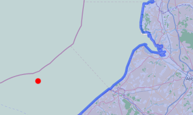
In this case the polygon that covers mainland France - which apparently has a hole in it. It also tells us that our point is 19065 meters away from the coast.
From this output, we find out which Timezone Identifier was associated with the nearest polygon so that we can find all other ares with the same Timezone Identifier just like before.
Nautical Time
In the case even the Aggregation Framework query doesn't return anything we have to assume that we are not in territorial waters and we need to calculate Nautical Time. Nautical Time is the "ideal" timezone for a given longitude. Each each zone is exactly 15° wide. The Greenwich time zone runs from 7.5°W to 7.5°E longitude. Although not technically linked to UTC (but rather GMT or UT1), in my example I will be using Timezone Identifiers using UTC. If you want to learn more about UTC vs GMT vs UT1, see my article Leap Seconds and What To Do With Them.
To calculate which UTC±x zone belongs to the current longitude, we can use the following code:
$ew1 = -7.5 + 15 * ceil(($center->p[0] - 7.5) / 15);
$ew2 = 7.5 + 15 * ceil(($center->p[0] - 7.5) / 15);

$offset = (int) (($center->p[0] - 7.5) / 15);
$sign = $offset < 0 ? '-' : '+';
We create a fake polygon to show the area:
$s[0] = array(
        '_id' => 'tz' . $offset,
        'l' => array(
                'type' => 'Polygon',
                'coordinates' => array( array(
                        array( $ew1,  85 ),
                        array( $ew1, -85 ),
                        array( $ew2, -85 ),
                        array( $ew2,  85 ),
                        array( $ew1,  85 ),
                ) ),
        ),
        'ts' => array(
                sprintf( "TZID=UTC%s%d", $sign, abs($offset) )
        ),
);
Which results in:

A demo is available at http://maps.derickrethans.nl/?q=timezone&zoom=5 and the code is available through https://github.com/derickr/3angle with the timezone maps specific parts at https://github.com/derickr/3angle/tree/master/maps-timezone
In a future version I would like to have all the timezones as shapefiles, including the territorial waters with regions and separate polygons for the Nautical timezones. Stay tuned for more!


Life Line
Created 2 benches
I hiked 11.3km in 3h31m08s
Updated a pub
Updated a pub
Updated 4 pubs; Confirmed a pub
Created a restaurant
I walked 0.8km in 9m31s
I walked 2.1km in 16m42s
I walked 4.7km in 48m42s
I walked 7.4km in 1h16m10s
Updated a fast_food
Updated a cafe, a pet shop, and a bench; Confirmed a cafe, a convenience shop, and a motorcycle_repair shop
I walked 5.0km in 1h2m27s
I walked 1.1km in 10m08s
Updated a cafe; Confirmed 3 convenience shops, a fast_food, and a laundry shop
Created a fitness_centre; Updated an event_caterer office and a social_facility; Confirmed a restaurant and a pharmacy
I walked 7.6km in 1h29m58s
Updated a pub
I walked 10.8km in 2h18m39s
Created 3 entrances
I walked 6.5km in 1h8m25s
Created 2 fast_foods, a convenience shop, and 2 other objects
I hiked 10.6km in 2h59m33s
I walked 3.2km in 1h17m20s
I walked 3.3km in 1h2m23s
Shortlink
This article has a short URL available: https://drck.me/whattime-a8d