
Walking: Wembley to Uxbridge
I have been walking SlowWays routes for about a year now, but I never put their reviews with photos on my own blog. I like owning my own content, so this year I will be publishing them here in a more prosaic form. So here is the story of my first walk in 2023, from Wembley to Uxbridge via Southall and Northolt.
Perhaps it wasn't the wisest day to go out for a walk, with drizzle forecasted for most of the day, with only a sliver of hope for a bit of sunshine in the afternoon. But it was the first Saturday of the year and I couldn't let a good opportunity for a walk slip.
As there were National Rail strikes going on, I decided to walk something in London, and opted for routes that I had never done, but were close to being verified — each SlowWays route needs three positive reviews for them to get verified (or "snailed").

And so I set off from Wembley along some residential roads before going along Ealing Road and past Alperton station towards the canal. The stint along the canal was very short, but I would return to it for a long stretch later on in the walk. Alperton is mostly dominated by low-height industrial areas, with lots of garages and body-work shops. After crossing the A40 at Perivale the walk became a lot nicer with at least some greenery on the left, before crossing Perivale Park with its golf course.
At the far left of the park some burly blokes let their aggressive looking dog of the lead, which promptly came sprinting right at me, but also luckily straight past me. I wasn't particularly pleased with this!

Then the route continued following the River Brent, where the path was fairly muddy, and crossing not just one, but two golf courses in the space of a few kilometres. I don't quite understand why there need to be so many, especially with the housing need that we have. I went a little off-course after crossing Greenford Road, but that was my own fault for not following the route precise enough. The last stretch to Southall was along a brick-walled public footpath.
This first section from Wembley to Southall was quite a nice walk, with some minor nits such as the Alperton industriousness, and that bloody dog!
I continued on this wet and drizzly winter morning to Northolt, continuing along it's busy "The Broadway", towards the Grand Union Canal, which it follows for most of the walk. It also shares a short section here with the Hillingdon Trail, which I previously walked. I would see more of that in the third section (Northolt to Uxbridge).

It's pleasant along the canal, with plenty of wild life and boaters to keep your attention, although it can get a little monotonous at times. At Northolt I crossed a bridge over the canal, and nearly fell on my bum as the tarmac was suddenly very slippery. Disaster averted, I then climbed up the hill into Belvue Park towards St. Mary's church and the gardens of the former Northolt Manor. The SlowWays route tried to make me go through a field, with a ditch, which was decidedly not possible as there was nearly a foot of water. There was however a nice path along the Northern edge which I followed to avoid having to go for a swim. After leaving the park, it was a short stretch along a road with a few shops and a lovely clock tower (with the wrong time) to Northolt underground station where this second section finished.
After leaving Northolt station with its clock tower and shops, the route starts off through Islip Manor Park. After a short stretch along residential roads, I crosses the A40 with a footbridge, and then it was mapped along a foot path straight through to the A4180. This path wasn't passable due to large amounts of water on the path, and my boots weren't high enough. Instead, I followed Compton Crescent and Vanbrought Crescent to by pass the impassable section.

On the other side of the fairly busy West End Road, the route continues first over a tarmac path, then a gravel path, and finally a dirt path through the woods, towards the Yeading Brook Meadows, where the paths were decidedly muddy, but still passable. It was here where the route also started (mostly) following the Hillingdon Trail again, through Ten Acre Wood, on top of banks along Yeading Brook, and then along the edge of the field. I had to make a minor detour here as the path was temporarily closed due to a heavy dead branch in a tree.
The next section was narrow, and also still muddy, but it wasn't a disaster. After climbing along a too narrow kissing gate, I did have to jump over a little stream though (and I didn't land on my behind).
The final section of the route then proceeds along residential roads. It is mapped to cut off a corner near Park Road/St Andrews Road, and although the path is there, I didn't spot it, and instead walked around the construction area. It's not enough of a bother to redo the SlowWays route as mapped, but I have updated OpenStreetMap to be more accurate here. I was pleased to see that much of the High Street is now pedestrianised. The route finished at Uxbridge station, which has a lovely interior.
And that concludes the first walk of the year!


Life Line
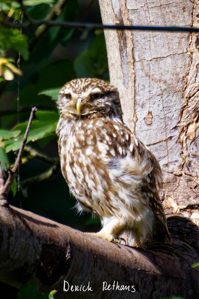
Little Owl owlet
This lovely owlet was quite easy to find in a London Park, with some help as they camouflage so well!
I saw its sibling too.
#BirdPhotography #BirdsOfFediverse #Photography #Nature #London #BirdsOfMastodon
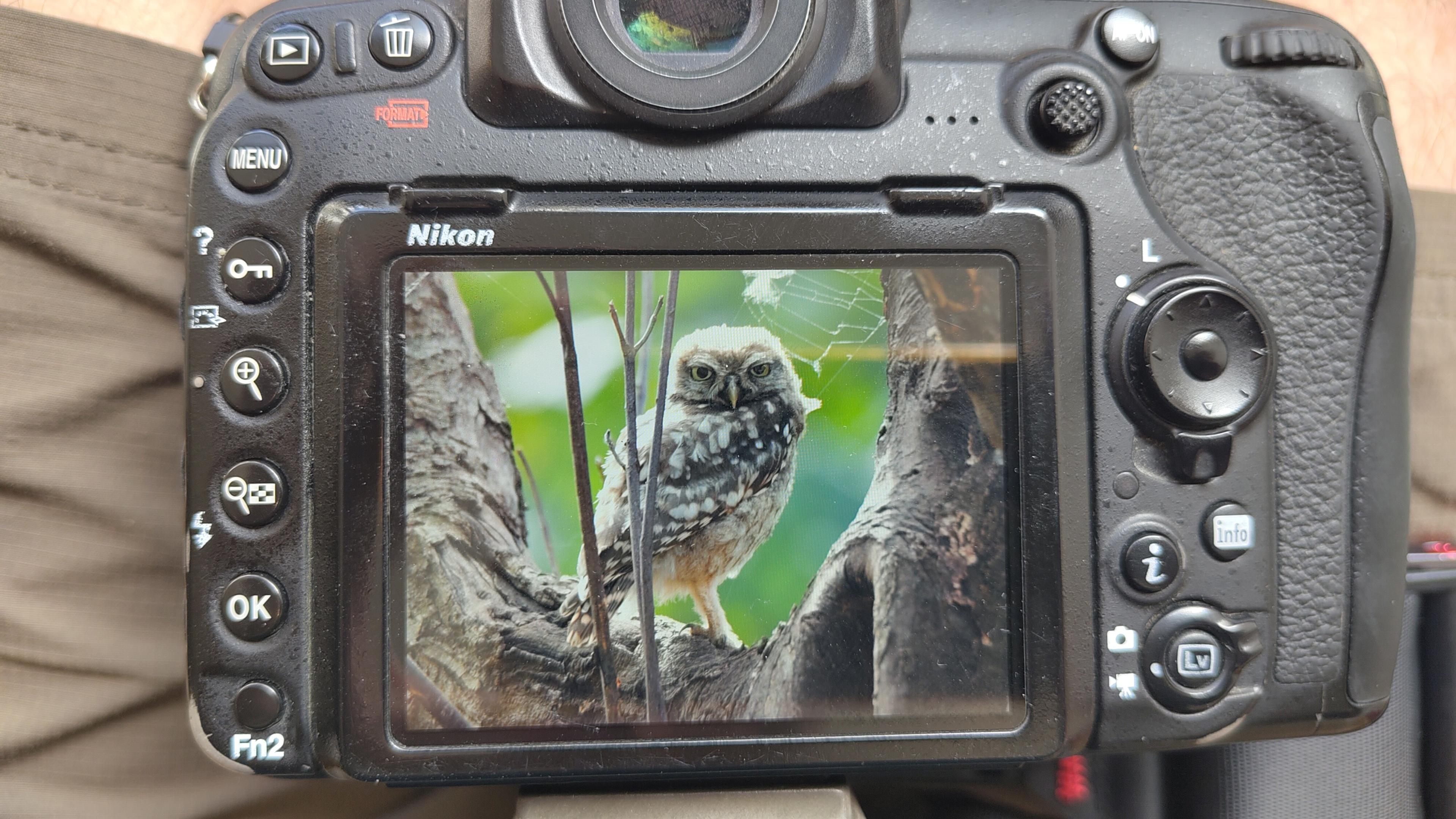
I went to a park (Bushy Park) to look for some owls.
I found Owls (Little and Tawny), but also a Green Woodpecker and two Kingfishers.
Snaps from my camera screen, and real photos will follow, but not of the Kingfishers as they were too far away and the photos are blurry.
#london #BirdPhotogaphy #BirdsOfMastodon #Birds #photography #BirdsOfFediverse #BushyPark
I hiked 13.8km in 4h44m12s
Created a chocolate shop and a restaurant; Updated 6 restaurants and an address; Confirmed 5 restaurants, a community_centre, and 3 other objects
Created a restaurant, a fast_food, and 2 other objects; Deleted a restaurant
I walked 8.5km in 1h31m45s
Created 2 buildings and a hairdresser shop; Updated a restaurant and an estate_agent office; Confirmed a cafe
I walked 2.2km in 38m09s
Merged pull request #1096
Bump actions/checkout from 6 to 7
Merged pull request #1095
Improve Tiverton Green mapping
Created 2 gates
I walked 7.1km in 1h23m15s
I walked 1.0km in 9m24s
Realign streets. They now have much less wide corners into each other.
Updated a fast_food
I walked 9.1km in 1h35m41s
I hiked 4.7km in 3h24m10s
I walked 6.7km in 1h12m03s
I walked 7.7km in 1h47m24s
Updated a pub
Updated a pub
Created a bar; Updated a bar; Confirmed a restaurant and a bar
Shortlink
This article has a short URL available: https://drck.me/web-uxb-hrs