
Walking the London LOOP - part 2
Back in October 2013, Morag and I started walking the London LOOP - with section 1. It took nearly four months before we embarked on the second section. The delay was mostly caused by the short days and the terrible weather we have had during the winter. But with the Sun returning and the days getting longer it was time to do part 2: Bexley to Jubilee County Park. We originally intended to do the walk on February 15th, but all the trains towards Kent were buggered due to lots of falling trees caused by the latest storm — hence our second attempt last Sunday. Why I thought it was a good idea to do this right after the PHP UK Conference is a bit of a mystery to me still.
Of course, the travel to the start of the walk was not as straightforwards as it could be. With lots of engineering work and bus replacement services. We ended up taking the train to Barnehurst and bussing it to Bexley—much better than the route that was suggested by National Rail Inquiries: train from Charing Cross to Plumstead, bus to Dartford, and then the train back to Bexley.

From Bexley startion we crossed under the railway and headed South. Just before getting to the river Cray, we walked through some woodland where a fair amount of trees had not survived the winter storms. Joining the river after a mile or so we noticed that it was still very high, and rather fast flowing. In fact, it was so high that many of the paths were either flooded—or very muddy. The muddy path opened up into the Stable and Footscray Meadows and a very lovely bridge, the Five Arches, crossing over the river Cray.


I think there was a bit more water in the meadows than there usually was. Or perhaps the locals tried to create an extra lake. In any case, there was no dry way out of the meadows into the direction we had to be going. The photo to the right just points out how much water we had to wade through. I estimate it was about 3 inches deep.

Past the meadows and All Saints Church we stopped in Sidcup for lunch. Although the route goes past a pub, we decided to skip and instead just pick a cafe in Sidcup itself. But not before we encountered this friendly horse.
Sidcup itself seems like a little village with not much going on, but lunch at Urban Food was decent. After filling up we continued the walk by finding Sidcup Place and crossing the A20 into Scadbury Park.

Scadbury Park is rather large and a local nature reserve. It is also old and has a ruined moated manor in the middle, which was owned by the Scathebury family. The LOOP as mapped on OpenStreetMap had the route go past the manor, but I found that was incorrect as shown by the sign posts on the route.


From Scadbury park we crossed into Petts Wood, or rather perhaps it should be called the Petts Mud Flats as there was nearly no space without mud — some times up to half a foot deep. An indication of the amount is visible in the image to the right. I don't think I've ever had this much mud on a walk actually.

This meant that we were a bit delayed and we would just miss the train home from Petts Wood station. When coming out of the woods we crossed multiple sets of train tracks. The section as shown on the left is just before the end point of second section in the Jubilee Country Park.
The weather was colder than the first section, but that was no surprise as it is February. At around 8°C there was a fair bit of wind, but we kept it dry.
For the full photo series of the LOOP, see my Flickr set.


Life Line
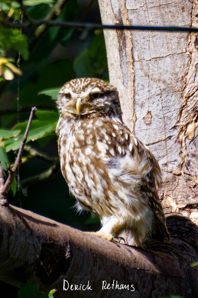
Little Owl owlet
This lovely owlet was quite easy to find in a London Park, with some help as they camouflage so well!
I saw its sibling too.
#BirdPhotography #BirdsOfFediverse #Photography #Nature #London #BirdsOfMastodon
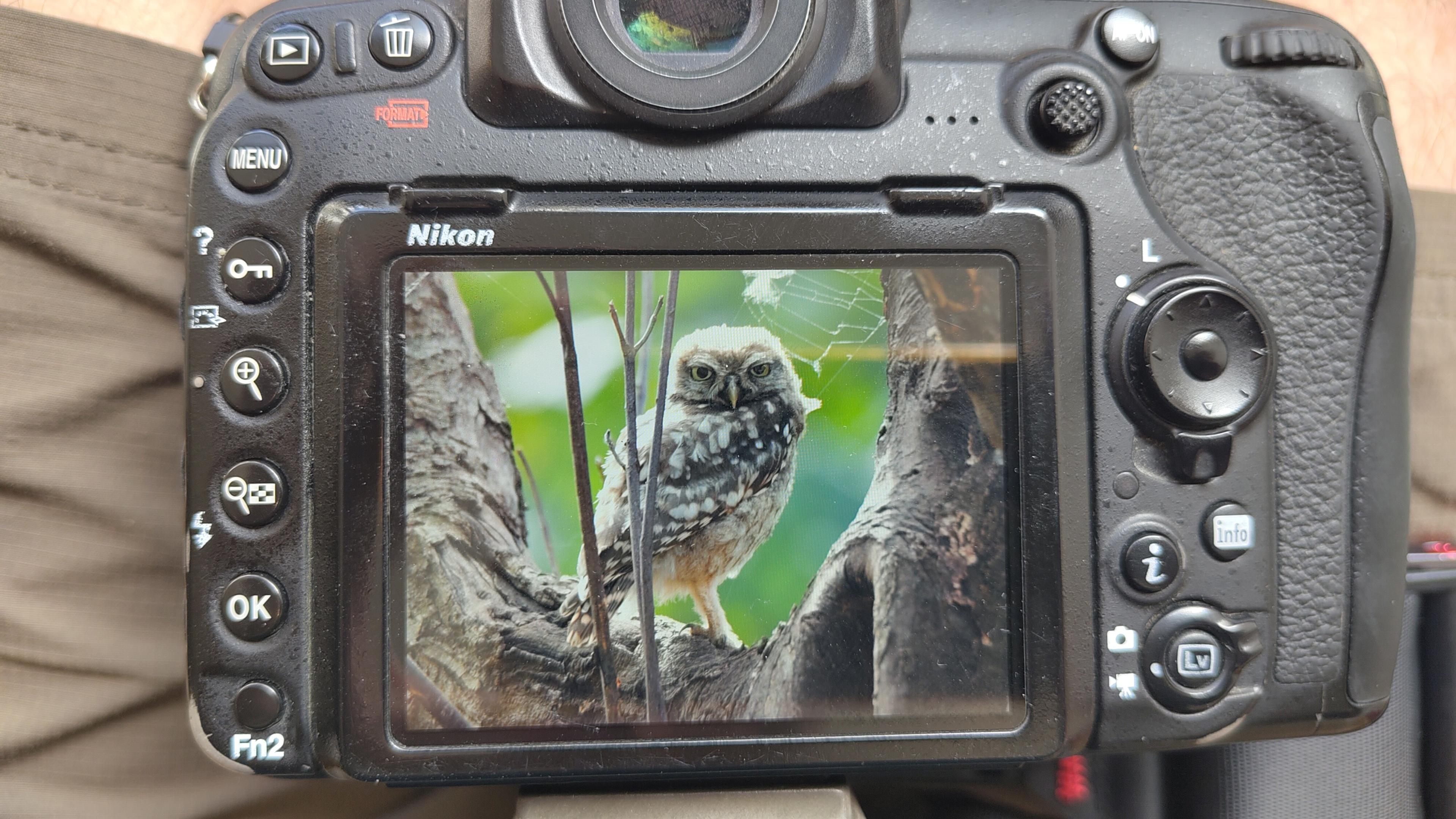
I went to a park (Bushy Park) to look for some owls.
I found Owls (Little and Tawny), but also a Green Woodpecker and two Kingfishers.
Snaps from my camera screen, and real photos will follow, but not of the Kingfishers as they were too far away and the photos are blurry.
#london #BirdPhotogaphy #BirdsOfMastodon #Birds #photography #BirdsOfFediverse #BushyPark
I hiked 13.8km in 4h44m12s
Created a chocolate shop and a restaurant; Updated 6 restaurants and an address; Confirmed 5 restaurants, a community_centre, and 3 other objects
Created a restaurant, a fast_food, and 2 other objects; Deleted a restaurant
I walked 8.5km in 1h31m45s
Created 2 buildings and a hairdresser shop; Updated a restaurant and an estate_agent office; Confirmed a cafe
I walked 2.2km in 38m09s
Merged pull request #1096
Bump actions/checkout from 6 to 7
Merged pull request #1095
Improve Tiverton Green mapping
Created 2 gates
I walked 7.1km in 1h23m15s
I walked 1.0km in 9m24s
Realign streets. They now have much less wide corners into each other.
Updated a fast_food
I walked 9.1km in 1h35m41s
I hiked 4.7km in 3h24m10s
I walked 6.7km in 1h12m03s
I walked 7.7km in 1h47m24s
Updated a pub
Updated a pub
Created a bar; Updated a bar; Confirmed a restaurant and a bar
Shortlink
This article has a short URL available: https://drck.me/loop2-avq