
Spatial Indexes: Fetching Data/SQLite
In a previous article I introduced 'The Flat Earth Model' and the 'The spherical Earth model'. In this article we're going to have a look at fetching a data set and importing them into a SQLite database to query from PHP. What better data set is there to import than all of the UK's pubs?
Getting the Data
In order to get a suitable data set we are going to use the data from the OpenStreetMap project. This project is mainly concerned with making an open map of the entire globe, but it also contains a vast database of points-of-interest (POI). OpenStreetMap contributes seems to be a big fan of pubs, and hence they are mapped really well. POIs can either be stored as a node (a single point with a geographical location) such as The Long Acre or as a closed way (an ordered collection of nodes where the first and last node are the same), such as Brondes Age.
I will demonstrate two methods to fetch the pubs in an XML format containing nodes and ways. The first method is with XAPI. XAPI is an interface to the OpenStreetMap database to allow users to query and filter items. In order to fetch data through it, you specify a bounding box and a predicate. A bounding box specifies the most Eastern, Southern, Western and Northern coordinates. The UK has roughly as bounding box 9.05°W, 48.77°N, 2.19°E, 58.88°N, or short: -9.05, 48.77, 2.19, 58.88. Fetching the data can simply be done by querying the server with wget:
wget -O pubs.xml 'http://xapi.openstreetmap.org/api/0.6/*[amenity=pub][bbox=-9.05,48.77,2.19,58.88]'
This is going to take a long time; and will most likely just not work or time-out. The current XAPI server, written in an obscure programming language called MUMPS, is extremely unreliable and is really slow. A new version of XAPI build in Java is on the way, but right now it's limited to 10 square degrees.
Luckily, there is an alternative in the form of parsing (an extract of) the planet file. The planet file is an enormous database dump of OpenStreetMap's data. The people at Geofabrik have extracts for specific parts of the world at http://download.geofabrik.de/osm/. From them I downloaded the europe/great_britain.osm.pbf file (274 MB) for my example. With a tool called Osmosis we can then filter out all pubs into a similar formatted XML file. I am only giving the command to do our task at hand, but a detailed usage guide for Osmosis is available too. The command runs in about four minutes and looks like:
./osmosis-0.38/bin/osmosis -v 5 \
\
--read-pbf file=great_britain.osm.pbf \
--tf reject-relations \
--tf accept-nodes amenity=pub,bar \
--tf reject-ways \
outPipe.0=POI \
\
--read-pbf file=great_britain.osm.pbf \
--tf reject-relations \
--tf accept-ways amenity=pub,bar \
--used-node \
outPipe.0=area \
\
--merge inPipe.0=POI inPipe.1=area \
--write-xml file=great_britain_pubs.osm
Importing the Data
The resulting XML file has two important elements: nodes and ways. The XML for The Long Acre looks like:
<node id="603112458"
  version="1" timestamp="2010-01-02T16:12:57Z"
  uid="1185" user="dankarran" changeset="3519803"
  lat="51.511831" lon="-0.126789">

  <tag k="amenity" v="pub"/>
  <tag k="name" v="The Long Acre"/>
</node>
Important here are the latitude (51.51°N) and longitude (0.12°W) and of course, the name of the pub in the tag element.
And the XML for Brondes Age (a way) is a bit more complex, and looks like:
<way id="72773168"
  version="2" timestamp="2011-01-31T10:07:45Z"
  uid="346" user="Tom Chance" changeset="7143502">

  <nd ref="863936779"/>
  <nd ref="863936774"/>
  <nd ref="863936777"/>
  <nd ref="863936796"/>
  <nd ref="863936791"/>
  <nd ref="863936768"/>
  <nd ref="863936779"/>
  <tag k="addr:housenumber" v="328"/>
  <tag k="addr:postcode" v="NW6 2QN"/>
  <tag k="addr:street" v="Kilburn High Road"/>
  <tag k="amenity" v="pub"/>
  <tag k="building" v="yes"/>
  <tag k="contact:email" v="brondesage@aol.com"/>
  <tag k="contact:phone" v="+44 20 76249010"/>
  <tag k="contact:website" v="http://www.brondesage.com/"/>
  <tag k="name" v="Brondes Age"/>
  <tag k="toilets" v="yes"/>
  <tag k="toilets:access" v="customers"/>
</way>
There is no latitude and longitude, but instead there are references to nodes (the nd elements). There is also a large collection of descriptive tags, such as addr:housenumber and contact:phone. In order to calculate the latitude and longitude of Brondes Age we can either take the correct approach by calculating the centroid or we can simply take the average latitude and longitude of all the nodes. To make things simple, I will take the simple approach.
In order to find the latitude and longitude of all the nodes, we simply scan through the file again and find all the nodes that correspond to the ref attribute of each nd element. We should disregard the last one of each way though, as it is the same as the first one.
SQLite
To start, we will use a very simple RDBMS: SQLite. We will still have to define a database schema. We can simply do that with:
derick@whisky:~$ sqlite pois.sqlite
sqlite> CREATE TABLE poi(id int, type int, lat float, lon float, name char, address char, cuisine char, phone char);
The importing of data then can be done by this "simple" script (after adjusting the path to eZ Components/ Zeta Components) with:
php parsepoi.php.txt great_britain_pubs.osm
After running the import script, there should be about 28000 POIs in the database.
Querying the Data
Once we have imported the POIs into our SQLite database, we are ready to query them. SQLite does not have a very extensive set of functions so we can not do the calculation in the query directly. Just to iterate from the previous article in this series, the formula for calculating the distance in a spherical Earth model is:
<?php
function distance($latA, $lonA, $latB, $lonB)
{
  // convert from degrees to radians
  $latA = deg2rad($latA); $lonA = deg2rad($lonA);
  $latB = deg2rad($latB); $lonB = deg2rad($lonB);

  // calculate absolute difference for latitude and longitude
  $dLat = ($latA - $latB);
  $dLon = ($lonA - $lonB);

  // do trigonometry magic
  $d =
    sin($dLat/2) * sin($dLat/2) +
    cos($latA) * cos($latB) * sin($dLon/2) *sin($dLon/2);
  $d = 2 * asin(sqrt($d));
  return $d * 6371;
}
?>
One solution would be to query the database, and then use the distance() function to filter out unwanted elements, like:
<?php
include 'distance.php';
require '/home/derick/dev/zetacomponents/trunk/Base/src/ezc_bootstrap.php';
$d = ezcDbFactory::create( 'sqlite://' . dirname( __FILE__ ) . '/pois.sqlite' );

// Centre point
$lat = 51.5375;
$lon = -0.1933;

// Distance (in km)
$wantedD = 0.25;

$q = $d->createSelectQuery();
$q->select( '*' )->from( 'poi' );
$s = $q->prepare();
$s->execute();

foreach ( $s as $res )
{
  $e = distance( $lat, $lon, $res['lat'], $res['lon'] );
  if ( $e < $wantedD )
  {
    echo sprintf( '%.3f,%.3f %-40s %.2f km away',
      $res['lat'], $res['lon'], $res['name'],
      $e ), "\n";
  }
}
?>
This will show all pubs in a 250 meter radius around 51.53°N, 0.19°W:
derick@whisky:/home/httpd/html/test/maps$ php fetch-sqlite-simple.php
51.538,-0.193 Mrs Betsy Smith                          0.01 km away
51.539,-0.195 The Cock Tavern                          0.24 km away
51.537,-0.192 The Old Bell                             0.10 km away
51.537,-0.192 The Westbury                             0.15 km away
Of course, this is not very efficient as all items are selected from the database, and then filtered out depending on their calculated distance. Luckily, SQLite supports user defined functions written in PHP. This would mean that we can increase performance a bit by letting PHP's internals call the distance function for every row:
<?php
include 'distance.php';
require '/home/derick/dev/zetacomponents/trunk/Base/src/ezc_bootstrap.php';
$d = ezcDbFactory::create( 'sqlite://' . dirname( __FILE__ ) . '/pois.sqlite' );

// Register SQLite function "dist" to our PHP function "distance".
$d->sqliteCreateFunction( 'dist', 'distance' );

// Centre point
$lat = 51.5375;
$lon = -0.1933;

// Distance (in km)
$wantedD = 0.25;

$q = $d->createSelectQuery();

// Use the user defined dist() function as additional column
$q->select( "*, dist($lat, $lon, lat, lon) as e" )
  ->from( 'poi' )
  ->where( "e < $wantedD" );

$s = $q->prepare();
$s->execute();

foreach ( $s as $res )
{
  echo sprintf( '%.3f,%.3f %-40s %.2f km away',
    $res['lat'], $res['lon'], $res['name'],
    $res['e'] ), "\n";
}
?>
The result is naturally the same as before.
Conclusion
In this installment we have seen how to retrieve information from OpenStreetMap's database and import them into SQLite for querying. In the next installment we will have a look at how to import and query with MySQL and PostgreSQL.

Comments
Interesting ! Just one thing, the link http://derickrethans.nl/files/parsepoi.php.txt don't work.
@Yannick: The script is there now. I had forgotten to commit it.

Life Line
Updated a restaurant
Created a bench
Updated a cafe
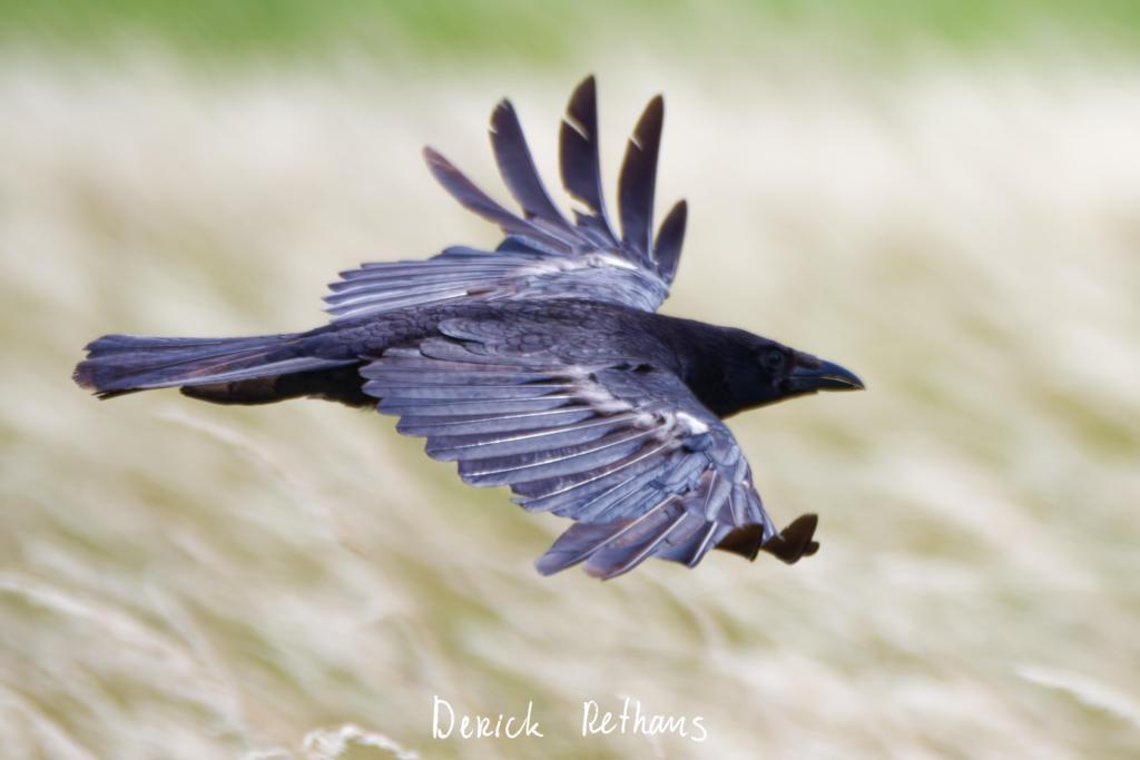
But I think my favourite photo was of this Carrion Crow in flight.
#Photography #BirdsOfFediverse #BirdPhotography #Nature
The new birds I saw, were mostly too far away to get good photos.
But I saw my first Spoonbill, Corn Bunting, and a flock of Black-tailed Godwits.
#BirdPhotography #BirdsOfFediverse

I had a lovely walk around RSPB Bowers Marsh yesterday, where I saw some expected birds, and a bunch of new species.
When I got there, there was this welcome committee of Starlings.
#BirdPhotography #nature #BirdsOfFediverse #Birds #Photography #RSPB

RSPB Bowers Marsh
Created 2 benches
I hiked 11.3km in 3h31m08s
Updated a pub
Updated a pub
Updated 4 pubs; Confirmed a pub
Created a restaurant
I walked 0.8km in 9m31s
I walked 2.1km in 16m42s
I walked 4.7km in 48m42s
I walked 7.4km in 1h16m10s
Updated a fast_food
Updated a cafe, a pet shop, and a bench; Confirmed a cafe, a convenience shop, and a motorcycle_repair shop
I walked 5.0km in 1h2m27s
I walked 1.1km in 10m08s
Updated a cafe; Confirmed 3 convenience shops, a fast_food, and a laundry shop
Created a fitness_centre; Updated an event_caterer office and a social_facility; Confirmed a restaurant and a pharmacy
I walked 7.6km in 1h29m58s
Updated a pub
Shortlink
This article has a short URL available: https://drck.me/spat-osm-sqlite-8la