
Mapping Lubumbashi
I spent last Saturday helping out HOT, the Humanitarian OpenStreetMap Team, to improve the map of Lubumbashi, Congo. This session focussed on digitizing the data that was acquired on the ground by volunteers (with pen and paper).
But this was not where the effort started. It started a few weeks ago when Jorieke set off to Lubumbashi to organise the mapping party. You can read more about this on the HOT blog.
In cooperation with Doctors without Borders/Médecins Sans Frontières UK (MSF UK), HOT organised this mapping effort, with the help of students from the University of Lubumbashi. The goal was to map the whole or at least as much as possible of the city of Lubumbashi.
At the start of the Mapathon, Harry Wood went through his usual spiel of introducing OpenStreetMap to the crowd. I dropped in the moment he was done, just in time to hear Ivan Gayton's talk on the work of MSF and their Congo mapping work. Mapping in Congo is not nearly as simple as it is here in London, where streets have street names that are neatly printed on street signs. This is not the case in Congo. There no street signs and often, people use names that are either not official, or have no official name anyway. The only way to find out how streets are called, is by asking the people living there!
MSF is interested in street name information, or more precisely, the neighbourhood names so that they have an identifier for statistical analysis for epidemiology. The accurate location names allows them to pinpoint for example cholera outbreaks, and hopefully in the future they can take preventative action against disease outbreaks.
The first step was creating a basic road layout, which was handled by a Mapathon in Berlin. Coordination of such large mapping efforts happen through the OSM Tasking Manager. You can see the job for Lubumbashi at http://tasks.hotosm.org/job/456 They did not stop at Lubumbashi though, and traced a whole of of other towns as well. And the mapping was not only remotely done from Berlin, but OpenStreetMap communities from Hungary, Togo, Burkina helped as well—a true global community.

Besides this initial road tracing job, there are a few other things still to trace too. If you have time, give them a hand for http://tasks.hotosm.org/job/459
With a basic road layout traced from areal images you have a rough idea on how a city looks like, but nothing beats a survey on the ground to see how things actually are. It is not always easy to spot things on areal imagery.
While remote mapping parties were nearing their completion of the road network, a group of volunteers from Department of Geography of the University of Lubumbashi went out into the neighbourhoods with FieldPapers to do the survey. Through hints from Ivan I understood that it took MSF some time to convince their professor to help out for free. He could hardly believe that some organisation was collecting all this data and then making it available for free. Not just for "no money", but also under an open license. Perhaps he was worried about what Google MapMaker is trying to do in underdeveloped countries—getting volunteers to collect data for them and then locking it up in GoogleMaps. Having open access to the data is of course much more valuable.
FieldPapers allows you to create atlases of areas. It divides this up into bite size chunks so that you can print them out and mark your survey information on the paper. For the Lubumbashi mapthon, we had an immense stack of those FieldPapers with notes on them. And our task was to go through this stack and digitize the notes on the map through an OpenStreetMap editor, such as JOSM. I think I managed to go through about 100 to 150 pages of them during the mapathon. One of the areas that I did was about 30 sheets of paper!
In the end, we made it through all of the FieldPapers. Task completed! But that does not mean we're finished. This effort was only a small section of Lubumbashi and the local volunteers are going to continue their effort. But they are also learning how to edit the data themselves. And that is the only sustainable way, but I will try to help out whenever I can!


Life Line
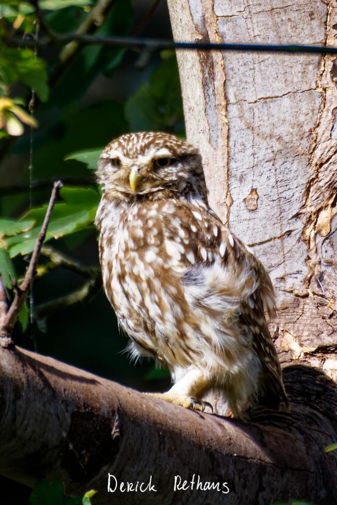
Little Owl owlet
This lovely owlet was quite easy to find in a London Park, with some help as they camouflage so well!
I saw its sibling too.
#BirdPhotography #BirdsOfFediverse #Photography #Nature #London #BirdsOfMastodon
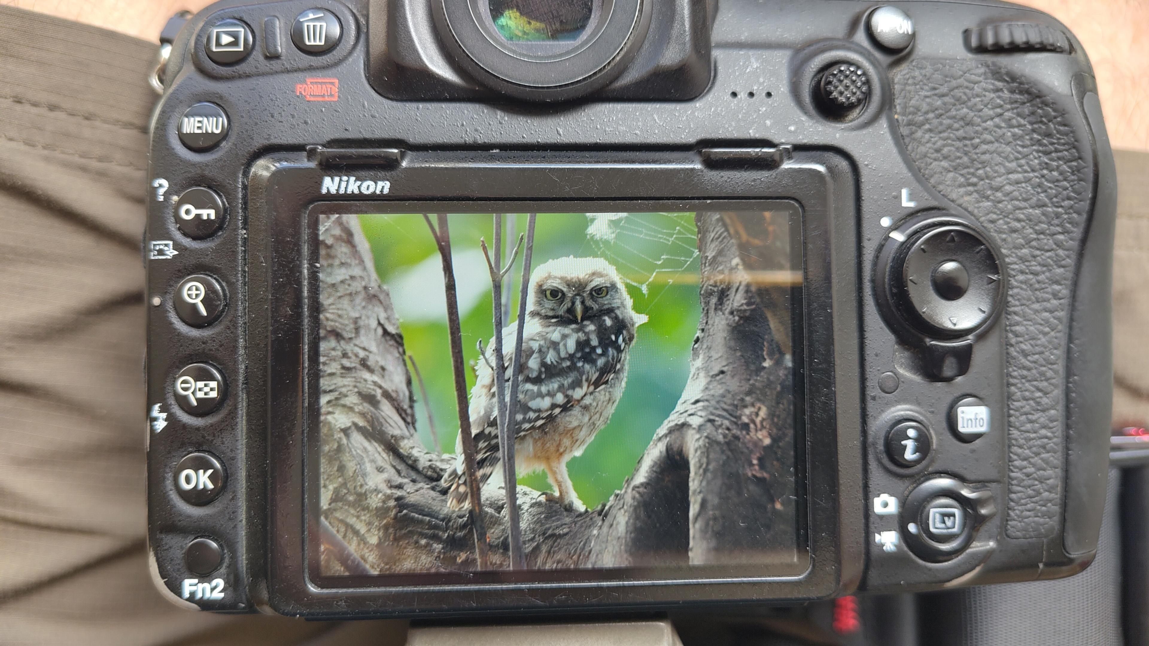
I went to a park (Bushy Park) to look for some owls.
I found Owls (Little and Tawny), but also a Green Woodpecker and two Kingfishers.
Snaps from my camera screen, and real photos will follow, but not of the Kingfishers as they were too far away and the photos are blurry.
#london #BirdPhotogaphy #BirdsOfMastodon #Birds #photography #BirdsOfFediverse #BushyPark
I hiked 13.8km in 4h44m12s
Created a chocolate shop and a restaurant; Updated 6 restaurants and an address; Confirmed 5 restaurants, a community_centre, and 3 other objects
Created a restaurant, a fast_food, and 2 other objects; Deleted a restaurant
I walked 8.5km in 1h31m45s
Created 2 buildings and a hairdresser shop; Updated a restaurant and an estate_agent office; Confirmed a cafe
I walked 2.2km in 38m09s
Merged pull request #1096
Bump actions/checkout from 6 to 7
Merged pull request #1095
Improve Tiverton Green mapping
Created 2 gates
I walked 7.1km in 1h23m15s
I walked 1.0km in 9m24s
Realign streets. They now have much less wide corners into each other.
Updated a fast_food
I walked 9.1km in 1h35m41s
I hiked 4.7km in 3h24m10s
I walked 6.7km in 1h12m03s
I walked 7.7km in 1h47m24s
Updated a pub
Updated a pub
Created a bar; Updated a bar; Confirmed a restaurant and a bar
Shortlink
This article has a short URL available: https://drck.me/lubum-ay8