
Ignite London: Crowd Sourcing a Map of the World
Almost two weeks ago, I gave a talk at Ignite London about OpenStreetMap, titled "Crowd Sourcing a Map of the World". Ignite's presentation style is 20 slides which automatically advance every 15 seconds. Having never done this before I actually wrote the whole talk out. The presentation that I gave slightly diverges from this but I thought it'd still be good to reproduce here. I did add some links to more information, and if you want to see the recording, you can find it at the end of this post.

1. This talk is about a project, started here in the UK with as its major goal to create a free map of the whole planet. From roads and motorways to country-side footpaths, restaurants and of course pubs. This talk is about OpenStreetMap, the free map of the world.

2. There are of course already plenty of mapping solutions available. Maybe one of the best maps can be acquired through Ordnance Survey. They can be regarded as the national authority on this subject. It's however expensive to get access to their maps, especially the very detailed maps from OS MasterMap. Additionally, it's only for the UK.

3. Besides the commercial solutions, you might wonder why we simply can't do with GoogleMaps? It's mostly freely available for use and also provides you with satellite imagery and StreetView. They even allow you in some areas to update the map through Google MapMaker.

4. But one thing Google doesn't give you access to, is the data behind the map. All you will ever see, is the rendered map tiles and perhaps some APIs to lookup locations and points of interest. Even for data that you have added yourself through MapMaker.

5. Both aspects; the cost of commercial maps, as well as the access to the data that is behind the map tiles is something that the OpenStreetMap project addresses. But which steps have to be taken to obtain this enormous amount of geographical data?

6. We start by getting our wellies and trusty GPS out. Maybe even some pen and paper. We find a location that looks rather empty on the map and travel to that area to see what's on the ground. This is step one: data gathering in the field.

7. In urban areas such as London the roads have often already been mapped and a GPS is not accurate enough to be useful. Then we just use pen and paper to record points of interest, such as shops, landmarks, restaurants and postboxes, my personal favourite.

8. In the country side, donated aerial imagery makes it possible for us to easily trace tracks and footpaths. However, you can't be sure whether the imagery is up-to-date, and you can't always see where fences, streams and local wild life create barriers.

9. In both situations, surveys are best done in groups: at mapping parties. It helps spread the workload and a larger area can be surveyed in one go. As an additional benefit, it allows us to go the pub and discuss our mapping adventures!

10. Doing a survey is important. We take photographs, video and notes with pen and paper of everything that seems to be of interest. This leaves a record that everything we map is actually existing and we can prove that nothing has been copied from other copyrighted maps.

11. After collecting the data, we enter it into the database. This includes basic information such as street names, but we also record whether a café has wheelchair access, or whether a pub has wifi. Updates to the map show up on the site close to real time.

12. Every map object has tags associated with it. Tags tell whether a line is a road, or perhaps a fence. All the tags are free form so you can generally add as much information about an object as you want. Sometimes however, this gets slightly out of hand and people tag pandas in trees and eyes on postboxes.

13. Once the data has been added to the map, we can make use of it. One of the primary uses is obviously showing the data as map tiles. But with all the extra data, we can generate maps that show all the information you're interested in-and nothing more.

14. Clockwise, we have four different visualisations of the map data: we have a cycling-specific style, a style that shows transport routes, a rendering with MapQuest's style sheets and even a water colours inspired style.

15. Having mentioned MapQuest; they were one of the first companies to make use of OpenStreetMap data. They provide, free of charge, map tiles with their own rendering style as well as an instance of Nominatim, OpenStreetMap's geolocation sister project.

16. Lots of companies have already switched to OpenStreetMap. The property search site Nestoria recently switched from using GoogleMaps to OpenStreetMap. Partly because of their costs, but also partly because "The maps are equal or better". geocaching.com, TfL's countdown website and Apple also use OpenStreetMap maps and data.

17. Although OpenStreetMap provides a free and editable map of the world, there are certain requirements for using the data as well. The most important one is that you always need to attribute the OpenStreetMap project.

18. In order to help people start using OpenStreetMap for their mapping needs, the Switch2OSM site has been launched. This website provides background information, case studies and technical information on how to use OpenStreetMap data.

19. Right now, OpenStreetMap has very good data coverage in the country, but we are not nearly finished. A lot of work still has to be done, and we rely on you to improve the data too, even if you add just a postbox.

20. In the last 5 minutes we have looked at what OpenStreetMap is, how the data is gathered and how the data is added to the map. Further more, we had a look at different use cases of the data. OpenStreetMap in the UK: Footpaths and pubs a speciality!
And then I planned showing the "Year of Edits" video, but that sadly didn't work out. I'm including it for good measure here though. (If you want it in HD, follow the link).
The video of the talk itself is at http://vimeo.com/41626116 and is embedded here:


Life Line
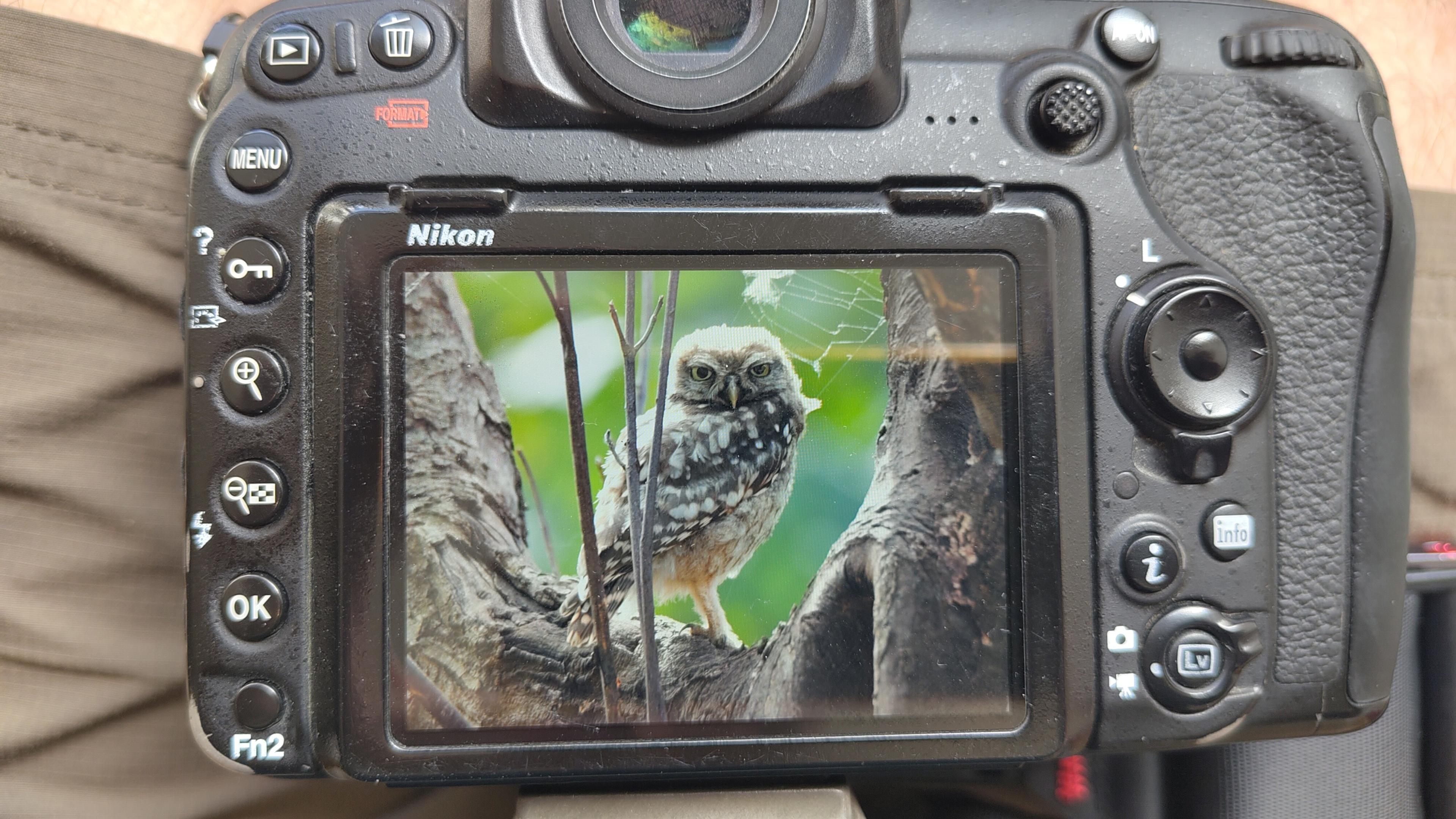
Little Owl owlet
This lovely owlet was quite easy to find in a London Park, with some help as they camouflage so well!
I saw its sibling too.
#BirdPhotography #BirdsOfFediverse #Photography #Nature #London #BirdsOfMastodon

I went to a park (Bushy Park) to look for some owls.
I found Owls (Little and Tawny), but also a Green Woodpecker and two Kingfishers.
Snaps from my camera screen, and real photos will follow, but not of the Kingfishers as they were too far away and the photos are blurry.
#london #BirdPhotogaphy #BirdsOfMastodon #Birds #photography #BirdsOfFediverse #BushyPark
I hiked 13.8km in 4h44m12s
Created a chocolate shop and a restaurant; Updated 6 restaurants and an address; Confirmed 5 restaurants, a community_centre, and 3 other objects
Created a restaurant, a fast_food, and 2 other objects; Deleted a restaurant
I walked 8.5km in 1h31m45s
Created 2 buildings and a hairdresser shop; Updated a restaurant and an estate_agent office; Confirmed a cafe
I walked 2.2km in 38m09s
Merged pull request #1096
Bump actions/checkout from 6 to 7
Merged pull request #1095
Improve Tiverton Green mapping
Created 2 gates
I walked 7.1km in 1h23m15s
I walked 1.0km in 9m24s
Realign streets. They now have much less wide corners into each other.
Updated a fast_food
I walked 9.1km in 1h35m41s
I hiked 4.7km in 3h24m10s
I walked 6.7km in 1h12m03s
I walked 7.7km in 1h47m24s
Updated a pub
Updated a pub
Created a bar; Updated a bar; Confirmed a restaurant and a bar

Shortlink
This article has a short URL available: https://drck.me/ignite-osm-9ey