
Downstream — Trip 2
It had been a few weeks since the previous walk. It had been quite hot and therefore I left it a little to continue along the Thames Path. Today was a lot cooler to start with, with some scattered showers predicted. As this was another weekend day I suspected rail engineering works—and indeed, there were no trains from Paddington to Oxford. The rail replacement bus which took me from Didcot Parkway towards the start in Oxford was luckily will organised, and I only ended up being about 15 minutes later than I originally had hoped for.
Day 4 — Oxford to Shillingford
It was fairly windy, and a little chilly when I left Oxford along the river. There were lots of rowers out on the Thames, which didn't come as a big surprise as that's what Oxford's stretch on the Thames Isis is known for. Not only were there lots of rowing clubs out, but also plenty of amateurs.
After a while it started to become darker and darker, and I started to wonder whether I was going to keep it dry. I encountered a pair of hikers also doing the Thames Path having a break near one of the boat houses. After having a chat, and avoiding a tree branch being blown out of the tree, I decided to continue and mentioned that I would chance getting rained upon. Without surprise, 5 minutes later it was pelting it down. I found some shelter under a few trees to put on my rain coat, but by the time I managed to put on my coat it was already dry. The additional humidity wasn't that great though.
Just before Abingdon, and its lock, there is a complicated section on the Thames Path that isn't very well signed. OpenStreetMap has the Thames Path (near) perfectly mapped, so it was easy enough for me to find the route, but I did assist somebody going in the opposite direction and explained where she had to go.
In Abingdon I had lunch at the Nag's Head, which is situated on its own island, Nag's Head Island. I opted for a traditional fish & chips, and had a pint of the local brew, called Nag's Island. Just when I was finishing lunch it started to drizzle a little bit, but it had already stopped by the time I had finished my visit to the little coder's room.
Unfortunately the drizzle did come back a few times over the next hours, while I was getting closer to the big towers of the Didcot power stations, which were looming on the horizon. Just before Culham I stopped to have a look at the Swift Ditch, and old short cut for the river Thames ignoring Abingdon. It is no longer in use, and very overgrown, but it was the fastest route for nearly a thousand years.
During the next bit of the walk, there were a great many locks to go past and over, until I came upon the river Thame. From the source at Thames' Head to where the river Thames meats the river Thame, the Thames is also called the Isis. Especially in Oxford do make a big deal out of that. On some Ordnance Survey maps you will still see "River Thames or Isis" for the whole stretch from the source to the Thame.
About 20 minutes later I arrived at my finish today at Shillingford, where I took the bus into Reading, via a bus-replacement bus in Wallingford, and via Henley-on-Thames as the schedule worked better for that. Why wait 30 minutes for a fast route that gets me into Reading 3 minutes earlier while it was very clearly going to rain soon? In Reading, the trains into London were unsurprisingly delayed, as they are so often.
Photos from my Adventure on the Thames Path are available on Flickr, and all videos on Vimeo. You can also see all the photos on a map.


Life Line
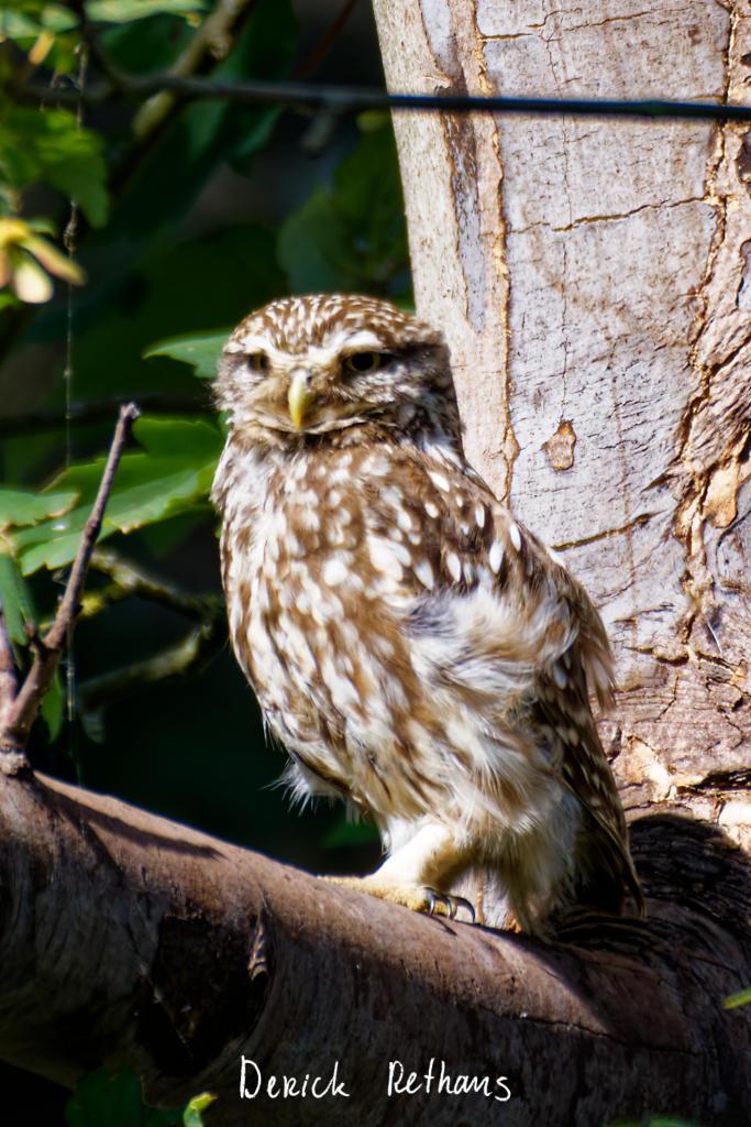
Little Owl owlet
This lovely owlet was quite easy to find in a London Park, with some help as they camouflage so well!
I saw its sibling too.
#BirdPhotography #BirdsOfFediverse #Photography #Nature #London #BirdsOfMastodon
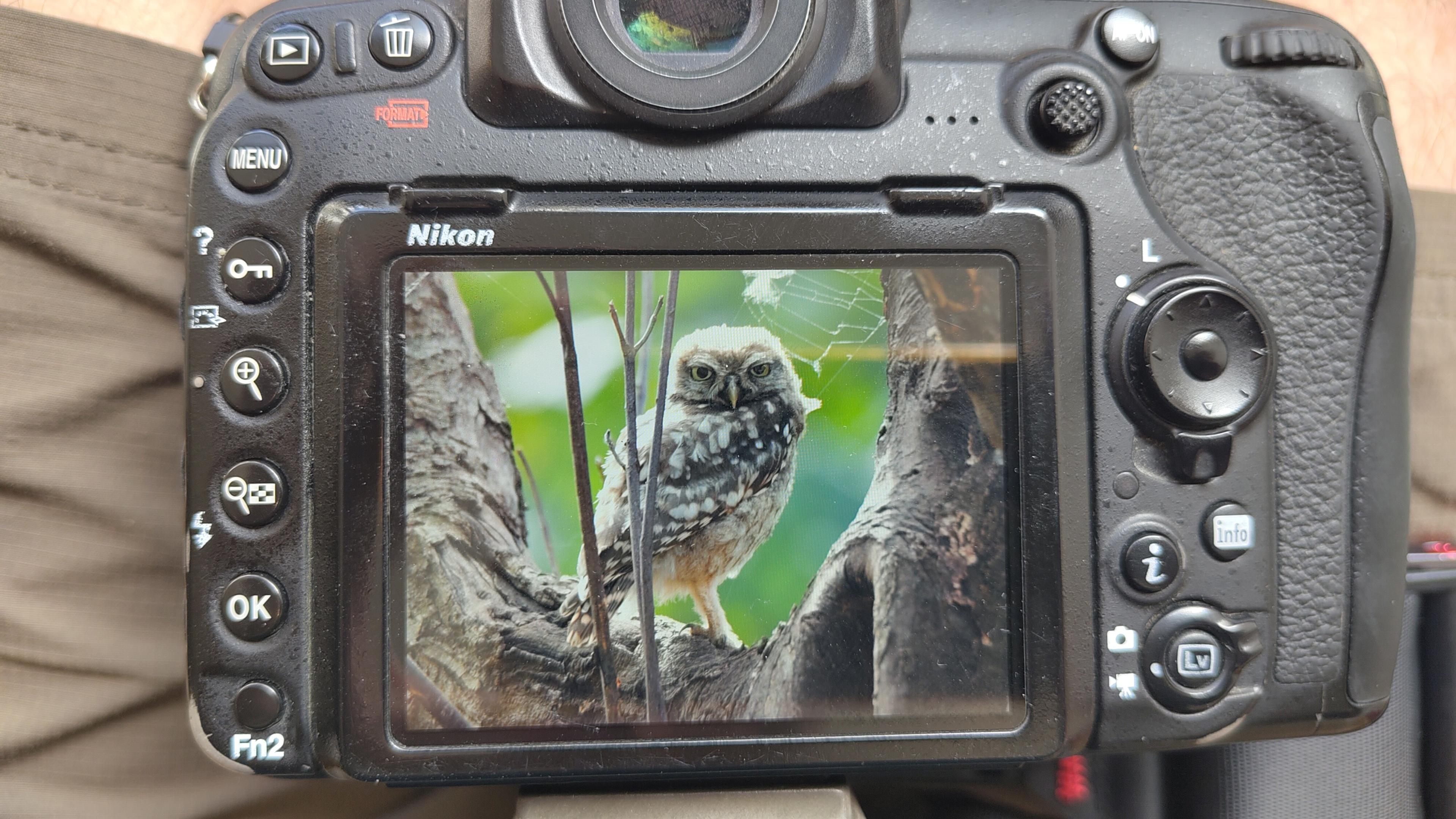
I went to a park (Bushy Park) to look for some owls.
I found Owls (Little and Tawny), but also a Green Woodpecker and two Kingfishers.
Snaps from my camera screen, and real photos will follow, but not of the Kingfishers as they were too far away and the photos are blurry.
#london #BirdPhotogaphy #BirdsOfMastodon #Birds #photography #BirdsOfFediverse #BushyPark
I hiked 13.8km in 4h44m12s
Created a chocolate shop and a restaurant; Updated 6 restaurants and an address; Confirmed 5 restaurants, a community_centre, and 3 other objects
Created a restaurant, a fast_food, and 2 other objects; Deleted a restaurant
I walked 8.5km in 1h31m45s
Created 2 buildings and a hairdresser shop; Updated a restaurant and an estate_agent office; Confirmed a cafe
I walked 2.2km in 38m09s
Merged pull request #1096
Bump actions/checkout from 6 to 7
Merged pull request #1095
Improve Tiverton Green mapping
Created 2 gates
I walked 7.1km in 1h23m15s
I walked 1.0km in 9m24s
Realign streets. They now have much less wide corners into each other.
Updated a fast_food
I walked 9.1km in 1h35m41s
I hiked 4.7km in 3h24m10s
I walked 6.7km in 1h12m03s
I walked 7.7km in 1h47m24s
Updated a pub
Updated a pub
Created a bar; Updated a bar; Confirmed a restaurant and a bar
Shortlink
This article has a short URL available: https://drck.me/downstream02-e5i