
Hunting for Postboxes (part 1)
The new year brings new hobby projects! In this year, I am going to try to photograph as many UK postboxes as I can. For this I am going to build some apps and overview maps, but I will write more about those later. A teaser for a future post is here to the left ;-).
The first thing that I want my application(s) to do is to give a description of where a postbox is located and this post is the tale of how I went about just doing that.
As my data source, I am using an OpenStreetMap extract for the London region. I import that through my "Import OSM data into MongoDB" script that I wrote about in an earlier article. The script is available on GitHub as part of the 3angle repository. The latest version is at https://raw.github.com/derickr/3angle/master/import-data.php and it also requires https://raw.github.com/derickr/3angle/master/classes.php for some GeoJSON helper classes and https://raw.github.com/derickr/3angle/master/config.php where you can set the database name and collection name (in my case, demo and poiConcat).
My goal is to get from a longitude/latitude pair to the closest postbox's reference number (EC2 201), a description like (On Paul Street, on the
corner with Epworth Street), and a direction and distance (East, 86m).
The first thing I do is to look-up the closest postbox. I can very easily do that with the following aggrgation query in MongoDB:
<?php
$m = new MongoClient( 'mongodb://localhost' );
$d = $m->selectDb( 'demo' );
$c = $d->selectCollection( 'poiConcat' );

$center = new GeoJSONPoint( (float) $_GET['lon'], (float) $_GET['lat'] );

$res = $c->aggregate( array(
        '$geoNear' => array(
                'near' => $center->getGeoJson(),
                'distanceField' => 'distance',
                'distanceMultiplier' => 1,
                'maxDistance' => 5000,
                'spherical' => true,
                'query' => array( TAGS => 'amenity=post_box' ),
                'limit' => 1,
        )
) );
I am using the aggregation framework instead of a normal query because the aggregation framework also can return the distance to the found object. The above returns $res, and our first result is located in $res['result'][0], which looks like:
array(
        '_id' => 'n905143645',
        'l' => array(
                'type' => 'Point',
                'coordinates' => array( -0.1960, 51.5376 ),
        ),
        'm' => array(
                'v' => 5,
                'cs' => 14576087,
                'uid' => 37137,
                'ts' => 1357659884,
        ),
        'ts' => array(
                0 => 'amenity=post_box',
                1 => 'operator=Royal Mail',
                2 => 'ref=NW6 14',
        ),
        'ty' => 1,
        'distance' => 162.15002059040299,
),
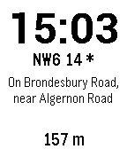
So postbox NW6 14 is 162.15 meters away from -0.1979, 51.5385 at -0.1960, 51.5376, as you can see in this image:

To find a description of where the postbox is, we first find the closest road:
$r = $res['result'][0];
$query = [
        LOC => [
                '$near' => $r['l']
        ],
        TAGS => new     MongoRegex(
                '/^highway=(trunk|pedestrian|service|primary|secondary|tertiary|residential|unclassified)/'
        )
];
$road = $c->findOne( $query );
highway is an OpenStreetMap tag that is also used for footpaths, service roads and alleys. These generally don't have names, so with the regular expression we restrict the query to only return "normal" roads. After executing this query, $road now contains:
array (
        '_id' => 'w4442243',
        'ty' => 2,
        'l' => array (
                'type' => 'LineString',
                'coordinates' => array (
                        array (
                                -0.2046823,
                                51.5346008,
                        ),
                        …
                        array (
                                -0.1940129,
                                51.5384693,
                        ),
                ),
        ),
        'ts' => array (
                'hgv=destination',
                'highway=secondary',
                'lit=yes',
                'name=Brondesbury Road',
                'note=Signed as maxweight 7.5T for goods vehicles except for access, so have tagged as hgv=destination',
                'ref=B451',
                'sidewalk=both',
                'source:ref=OS OpenData StreetView',
        ),
        'm' => array (
                'v' => 15,
                'cs' => 18802367,
                'uid' => 37137,
                'ts' => 1384017096,
        ),
)
As an image this looks like:
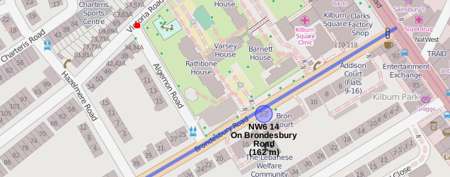
We are interested only in the name (name=Brondesbury Road) and the geometry (l). Right now, we can already assemble the description NW6
14, on Brondesbury Road. But we also want to know the closest cross road, which we can find by finding all roads that intersect with our geometry (in l) by running the following query:
$q = $c->find( [
        'l' => [
                '$geoIntersects' => [ '$geometry' => $road['l'] ]
        ],
        'ts' => new MongoRegex(
                '/^highway=(trunk|pedestrian|service|primary|secondary|tertiary|residential|unclassified)/'
        ),
        '_id' => [ '$ne' => $road['_id'] ],
] );
This returns nineteen roads. An extract looks like:
array(19) {
        'w4211713' => array(5) {
                '_id' => string(8) "w4211713"
                'ty' => int(2)
                'l' => array(2) {
                        'type' => string(10) "LineString"
                        'coordinates' => array(22) { ... }
                }
                'ts' =>
                array(4) {
                        [0] => string(19) "highway=residential"
                        [1] => string(15) "maxspeed=20 mph"
                        [2] => string(23) "name=Brondesbury Villas"
                        [3] => string(13) "sidewalk=both"
                }
                …
        }
        'w245650577' =>
        array(5) {
                '_id' => string(10) "w245650577"
                'ty' => int(2)
                'l' => array(2) {
                        'type' => string(10) "LineString"
                        'coordinates' => array(5) { ... }
                }
                'ts' =>
                array(6) {
                        [0] => string(15) "highway=primary"
                        [1] => string(7) "lit=yes"
                        [2] => string(15) "maxspeed=30 mph"
                        [3] => string(22) "name=Kilburn High Road"
                        [4] => string(6) "ref=A5"
                        [5] => string(13) "sidewalk=both"
                }
                …
        }
}
As an image this looks like:
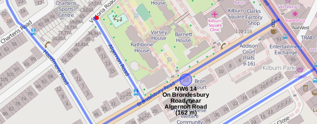
We are only interested in the roads that have a name and have a different name than the road we have run the intersection query for. In some cases, OpenStreetMap splits up a road in more than one segment carrying the same name. We discard both those in a loop and are then left with an array of intersecting road IDs in the $intersectingWays variable:
$intersectingWays = array();
foreach ( $q as $crossRoad )
{
        $crossTags = Functions::split_tags( $crossRoad[TAGS] );
        if ( !in_array( "name={$roadName}", $crossRoad ) && array_key_exists( 'name', $crossTags ) )
        {
                $intersectingWays[] = $crossRoad['_id'];
        }
}
With these IDs, we then search for the closest road(s) to the initially found postbox location:
$res = $c->aggregate( array(
        '$geoNear' => array(
                'near' => $r['l'],
                'distanceField' => 'distance',
                'distanceMultiplier' => 1,
                'maxDistance' => 5000,
                'spherical' => true,
                'query' => [
                        '_id' => [ '$in' => $intersectingWays ],
                        'ts' => [ '$ne' => "name={$roadName}" ]
                ],
                'limit' => 1,
        )
) );
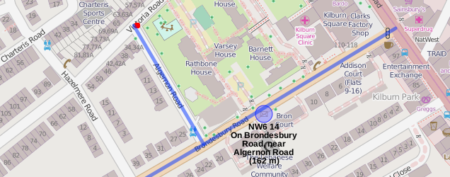
Again, the result in $res is in a similar format as before, so I won't repeat that. We use the aggrgation framework again so that we also get the distance of this intersecting road to the originally found postbox location. Depending on the distance to the intersecting road, we either use on the
corner of <roadname> (less thatn 25m) or near <roadname> if it's further away than 25m. For our example postbox, that makes NW6 14, on Brondesbury
Road, near Algernon Road which is illustrated by this image:
The full code for this example can be found at https://github.com/derickr/3angle/tree/master/maps-postbox and you see it in action (for London) at: http://maps.derickrethans.nl/?l=postbox,lat=51.5&lon=-0.128&zoom=17

Comments
Matthew Somerville's site provides a map of postboxes which I believe includes those that are NOT in OpenStreetMap. My understanding is that he is using the data from a FOI request
http://dracos.co.uk/made/nearest-postbox/
https://www.whatdotheyknow.com/request/location_of_every_post_box_that#incoming-1164
https://www.whatdotheyknow.com/request/royal_mail_post_box_types_collec#incoming-31588
In regards to my previous comment, the following appears to include grid reference locations (that could be converted to lat&lon):
https://www.whatdotheyknow.com/request/postbox_data_in_central_collecti_2
If you add these to your app then you could also use this to find postboxes not yet added to OSM :-)
I do something similar in India. Check http://openbangalore.org/postbox/
I am in the process of uploading the data to OpenStreetMap.
Some years ago I wrote about hunting out postboxes for the UK, I'm not so obsessed now. http://www.livingwithdragons.com/2009/06/my-postbox-obsession
Flickr has a lot of photos of UK postboxes, and I think you can extract some via the reference in machine tags.
Many people don't accept data from FOIA requests as being free enough of copyright for most uses (a FOIA response does not equal a public domain release), and the data quality is rather limiting in most cases.
Great technical write up Derick. I have an idea what your project might be so I'll keep a listen out for it's release.

Life Line
Updated a restaurant; Confirmed a bar and a restaurant
Updated a pub
Updated a restaurant
Updated a vacant business
Updated 2 bars, a deli shop, and a pub
Confirmed a supermarket shop
Updated a bar
Updated a bar
Updated a pub
Updated a bar
I've just finished reading "Schoofhondjes" (lapdogs, in Dutch).
The "Schoof" refers to the previous Dutch prime minister Dick Schoof, being the lapdog of Geert Wilders.
A great collection of columns, although I did need to Google some of the names and references as I hadn't heard about all of them!

Updated a bar; Confirmed a restaurant
Updated 3 restaurants, a vacant shop, and a bar; Confirmed a cosmetics shop, a cafe, and 2 other objects
Created 2 benches and 2 waste_baskets
Deleted a cycle_barrier
Put Kilburn Park station node in a more representable location (not at the back of the building where you can't get in)
Merge branch 'v2022'
Go with 2022.17
Merge branch 'v2022'
Update PHP merging script
Update data to 2026c
Kensal Green sidewalks: Fix alignment and connectivity near station; don't map sidewalks as separate on residential streets for just this tiny section; extend sidewalk mapping on Chamberlayne Road
New building
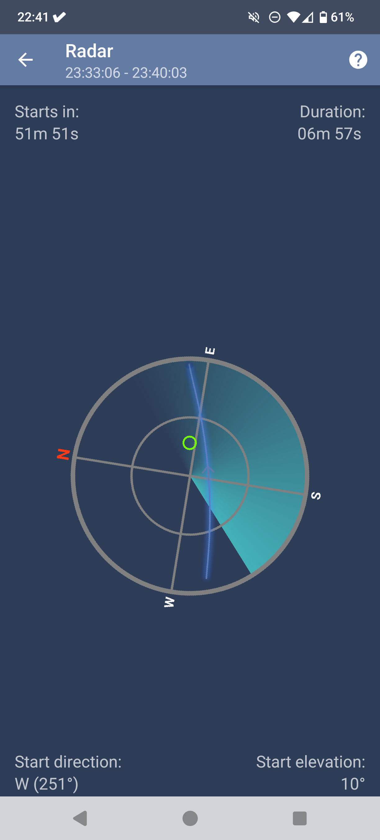
If you're in London (or Southern England) the ISS is going to make a fly over pass between 23:30 and 23:40 (a little earlier for West of London).
If you're further North than London, the ISS shows further South.
Almost straight overhead. It's going to be bright.
#ISS #SpaceStation #SpaceFlight
Shortlink
This article has a short URL available: https://drck.me/postbox1-auc