
Address lookups with Leaflet and Nominatim
I recently wrote a patch for joind.in to add a map of an event's location to the event detail page. With the same patch, I also replaced the location part of the event edit page with a solution that uses JQuery, Leaflet as map API, OpenStreetMap tiles and Nominatim for doing address lookups. This article forms a small tutorial on how to use this same set-up yourself.
The Basics
To start, we create a new directory for our project:
mkdir addresses
cd addresses
Then I downloaded the Leaflet and jQuery libraries and extracted them in the js directory of the project:
mkdir js
curl -L https://github.com/CloudMade/Leaflet/zipball/v0.4.5 -o leaflet.zip
unzip leaflet.zip
mv CloudMade-Leaflet-*/dist/* js
rm -rf CloudMade-Leaflet-*
rm leaflet.zip
curl http://code.jquery.com/jquery-1.8.2.min.js -o js/jquery-1.8.2.min.js
As first step, we are simply going to show a map on a web page. The map is going to be full screen, and will not have any bells and whistles. The code to embed a map is small, but we will separate it into three files for clarity: a CSS file for our styles (site.css), an HTML file for the structure (index.html) and a JS file for all our JavaScript functions (js/map.js).
Let's start with the HTML file:
<html>
  <head>
    <title>Leaflet and Nominatim example</title>

    <link rel="stylesheet" href="js/leaflet.css" />
    <!--[if lte IE 8]><link rel="stylesheet" href="js/leaflet.ie.css" /><![endif]-->
    <link rel="stylesheet" type="text/css" href="site.css">

    <script src="js/leaflet.js"></script>
    <script src="js/jquery-1.8.2.min.js"></script>
  </head>
  <body>
    <div id="map"/>
    <script src="js/map.js"></script>
  </body>
</html>
This HTML file includes the Leaflet and jQuery libraries, as well as the default CSS file that Leaflet needs. We are also including our own CSS file (site.css):
body {
  margin: 0;
}
div#map {
  width: 100%;
  height: 100%;
}
In the body of the HTML file, we place a <div> as contained for the map, and then include a JavaScript file that is responsible for embedding them map:
var map;
function load_map() {
map = new L.Map('map', {zoomControl: false});
var osmUrl = 'http://{s}.tile.openstreetmap.org/{z}/{x}/{y}.png',
osmAttribution = 'Map data © 2012 <a href="http://openstreetmap.org">OpenStreetMap</a> contributors',
osm = new L.TileLayer(osmUrl, {maxZoom: 18, attribution: osmAttribution});
map.setView(new L.LatLng(51.538594, -0.198075), 12).addLayer(osm);
}
window.onload = load_map;
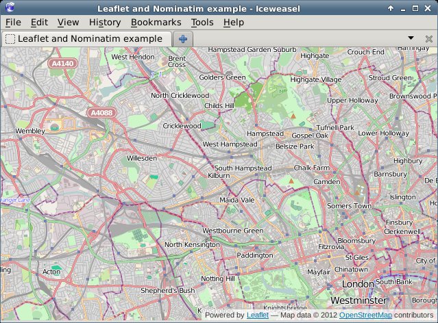
If you request the index.html page now through the browser, you will see something like:
Adding the Address Search
In order to add an address lookup form, we need to add more HTML. Our HTML will feature an input box (for the address), a submit button, and a place holder to show our results in. We add this code between the <div id="map"/> and the <script... tags:
<div id="search">
  <input type="text" name="addr" value="" id="addr" size="10" />
  <button type="button" onclick="addr_search();">Search</button>
  <div id="results"/>
</div>
To style this, we add the following at the end of our CSS file:
div#search {
  background-color: white;
  position: absolute;
  bottom: 40px;
  left: 40px;
  width: auto;
  height: auto;
  padding: 10px;
}
div#search input {
  width: 200px;
}
div#results {
  font-style: sans-serif;
  color: black;
  font-size: 75%;
}
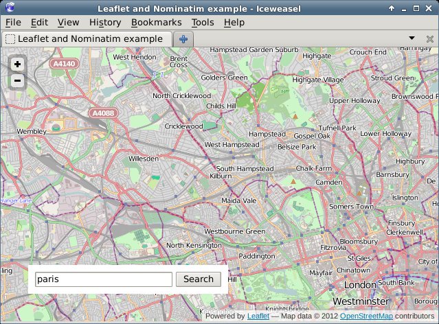
If we reload the page in our browser, we will see something like:
Now the only thing left to do is to implement the addr_search function. In our JS file (js/map.js) we add before window.onload = load_map; the following lines (split over multiple sections in this tutorial):
function addr_search() {
  var inp = document.getElementById("addr");

  $.getJSON('http://nominatim.openstreetmap.org/search?format=json&limit=5&q=' + inp.value, function(data) {
This above line uses jQuery's AJAX capabilities to request a URL, parse the JSON result and issue a callback if it worked. We query Nominatim here, with as format json and limiting the result to 5 items. Nominatim also supports other parameters, which are documented here.
var items = [];

$.each(data, function(key, val) {
  items.push(
    "<li><a href='#' onclick='chooseAddr(" +
    val.lat + ", " + val.lon + ");return false;'>" + val.display_name +
    '</a></li>'
  );
});
For each of the items in our result, we create an <li> element which has an <a href containing a call to a JavaScript function (chooseAddr). This function is responsible for re-centering the map according to the picked latitude and longitude.
    $('#results').empty();
    if (items.length != 0) {
      $('<p>', { html: "Search results:" }).appendTo('#results');
      $('<ul/>', {
        'class': 'my-new-list',
        html: items.join('')
      }).appendTo('#results');
    } else {
      $('<p>', { html: "No results found" }).appendTo('#results');
    }
  });
}
This processes the results that came back from Nominatim. If there are results, we shows those including a Search results: header, and if there are no results, we show No results found.
Then we need to add one more function, the chooseAddr function which looks like:
function chooseAddr(lat, lng, type) {
  var location = new L.LatLng(lat, lng);
  map.panTo(location);

  if (type == 'city' || type == 'administrative') {
    map.setZoom(11);
  } else {
    map.setZoom(13);
  }
}
We simply use the latitude and longitude from the function invocation, and in order to make things slightly nicer we zoom in a bit less if the item type is either a city or an administrative border. As each of the returned results actually includes a full bounding box, we probably can use that to zoom in better, but I will leave that for your own experiments - you'd want the panInsideBounds() method of Leaflet's Map class for that.
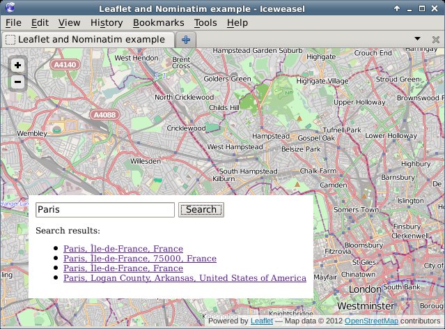
In the end, if we click on the Search button, a list is presented of all our search results:
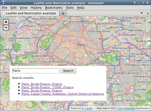
And after clicking one of the links, we see the map centered on Paris:
The code for this example is available on github in my osm-tools repository at https://github.com/derickr/osm-tools/tree/master/leaflet-nominatim-example


Life Line
Created 2 waste_baskets; Updated 2 bus_stops and 2 crossings
I hate this timeline.
For @fridaynightdinners I wanted to look up what the difference between Raviolo and Girasolo is.
DuckDuckGo's (non-ai variant) top three results are all AI generated content with AI generated author images, bio, and "flair".
I want stuff written by *humans*, not this AI slop BS.
Created 3 waste_baskets; Updated a waste_basket
Updated 6 crossings
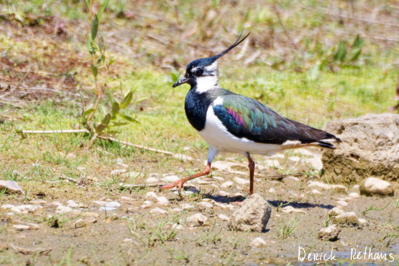
Northern Lapwing On The Move
This dapper bird is having a stroll looking for lunch. I like the iridescence in its wings.
#BirdPhotography #BirdsOfFediverse #Nature #Photography #London #BirdsOfMastodon
Created a vending_machine
Updated a bus_stop
I hiked 5.4km in 2h35m46s
I walked 2.2km in 27m13s
I walked 1.6km in 32m29s
I walked 3.3km in 34m33s
Updated a confectionery shop, a massage shop, and 2 other objects; Deleted a books shop
I hiked 7.0km in 4h21m00s
Updated a deli shop and a pet_grooming shop
I walked 4.2km in 49m42s
I walked 1.4km in 10m14s
I walked 2.2km in 1h43m13s
I walked 4.4km in 1h25m00s
Updated a cafe
Updated a bar
I walked 1.7km in 19m07s
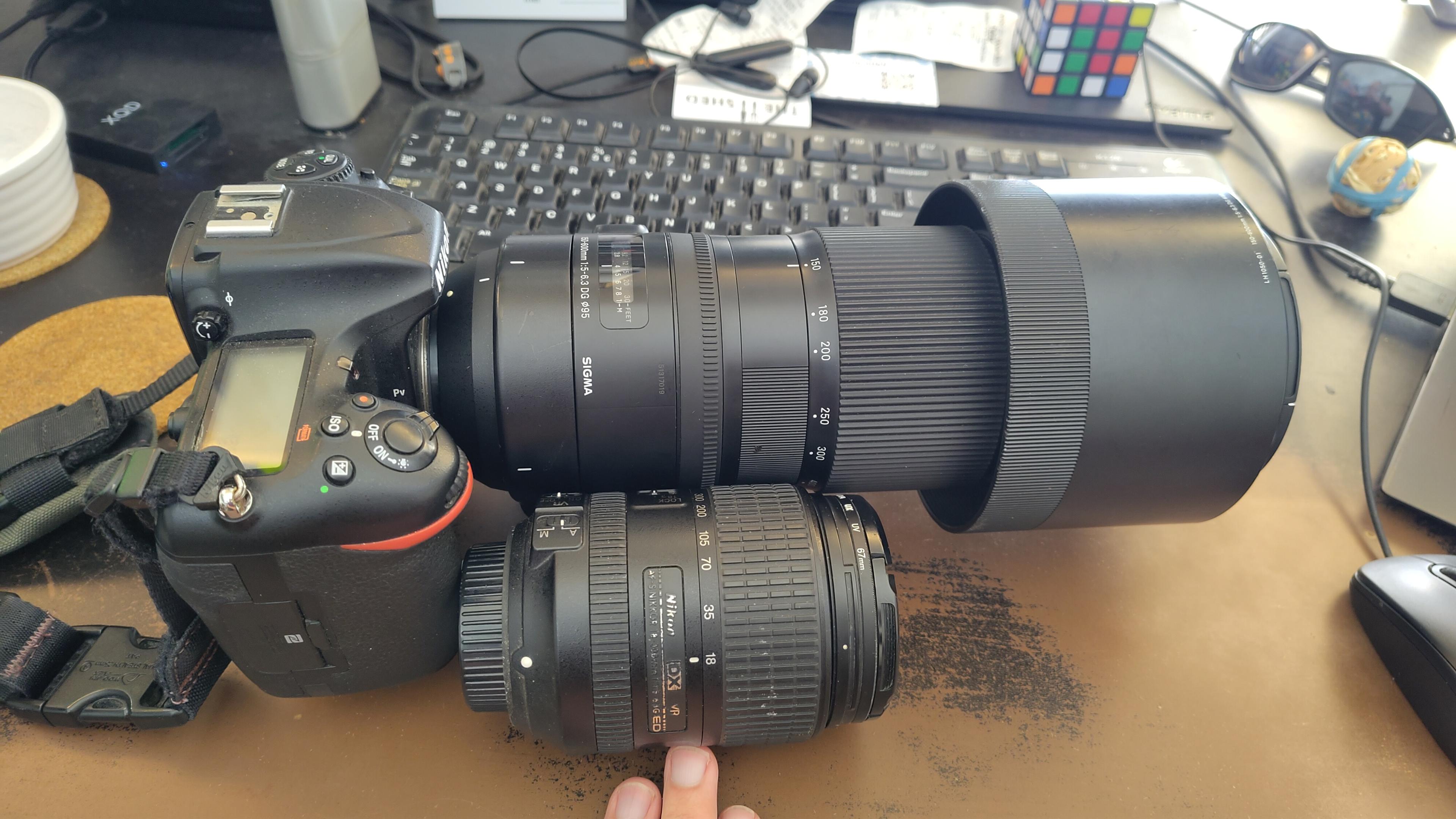
I got a new lens. It's a little bit larger, and loads heavier, than my older one.
#photography #naturephotography
I walked 1.6km in 15m10s

Shortlink
This article has a short URL available: https://drck.me/addrlookup-9mg