
Flat vs. Sphere
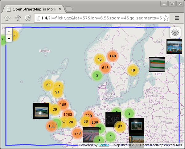
For the preparation of my Finding Pubs... (and other things) presentation that I gave at the PHP NorthWest usergroup some time ago I created a demo that shows all my flickr photos on a map. For example like:
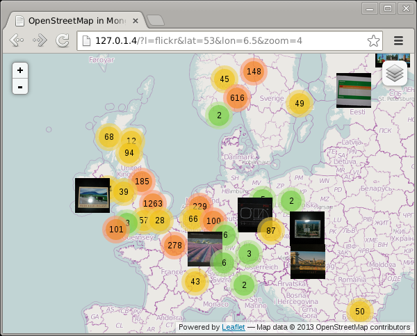
This example shows photos in the UK, Norway and Sweden as well as in Paris.
In order to not find too many photos that are not going to be in the portion of the world that the display covers, I add a bounding box to my find() query:
$polygon = GeoJSONPolygon::createFromBounds(
        min( 90, (float) $_GET['n'] ),
        min( 180, (float) $_GET['e']) ,
        max( -90, (float) $_GET['s'] ),
        max( -180, (float) $_GET['w'] )
);

$c = $d->selectCollection( 'flickr' );
$query = array(
        LOC => array(
                '$geoWithin' => array(
                        '$geometry' => $polygon->getGeoJSON(),
                ),
        ),
);
$s = $c->find( $query )->limit( 8000 );
The North, East, South and West points are being passed as argument to the fetch-poi.php script like: http://127.0.1.4/maps-flickr/fetch-poi.php?n=65.44000165965534&e=32.51953125&s=46.07323062540838&w=-19.51171875
Now if we scroll up a bit to include Iceland in the map, then we see that the photos in Paris disappear:
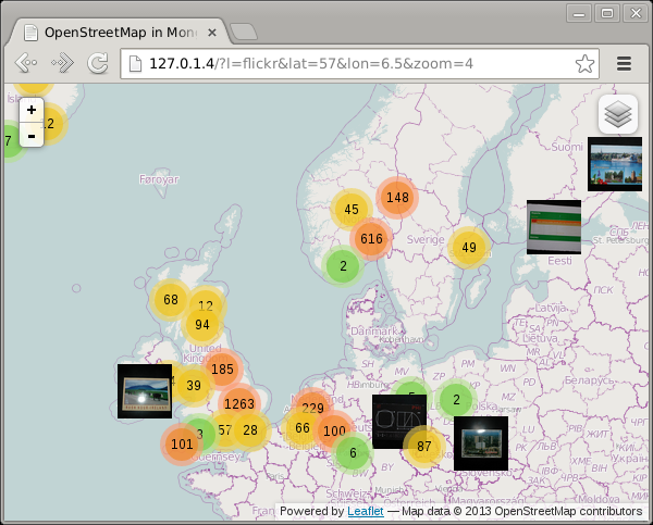
How is that possible? Let's first see what our polygon looks like:
<?php
include 'classes.php';

$_GET = array(
        'n' => 65.44000165965534,
        'e' => 32.51953125,
        's' => 46.07323062540838,
        'w' => -19.51171875,
);

$polygon = GeoJSONPolygon::createFromBounds(
        min( 90, (float) $_GET['n'] ),
        min( 180, (float) $_GET['e']) ,
        max( -90, (float) $_GET['s'] ),
        max( -180, (float) $_GET['w'] )
);

var_dump($polygon);
?>
Which outputs:
class GeoJSONPolygon#1 (1) {
  public $pg =>
  array(1) {
        [0] =>
        array(5) {
          [0] =>
          array(2) {
                [0] => double(32.51953125) [1] => double(65.440001659655)
          }
          [1] =>
          array(2) {
                [0] => double(-19.51171875) [1] => double(65.440001659655)
          }
          [2] =>
          array(2) {
                [0] => double(-19.51171875) [1] => double(46.073230625408)
          }
          [3] =>
          array(2) {
                [0] => double(32.51953125) [1] => double(46.073230625408)
          }
          [4] =>
          array(2) {
                [0] => double(32.51953125) [1] => double(65.440001659655)
          }
        }
  }
}
The 5 array elements in here reflect in order the North East point, the North West point, the South West point, the South East point and again the North East point. If we draw lines between those points on the map, we find:
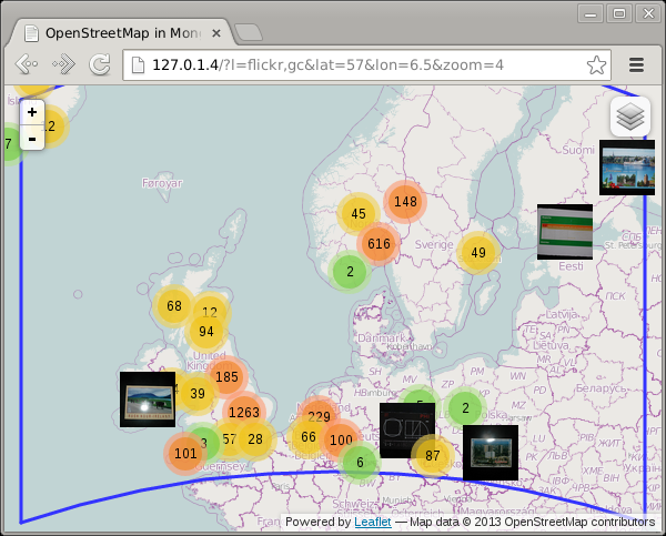
Which instantly shows you why I got missing photos! As you can see, the shortest line between vertical lines is a straight line on a sphere, but the horizontal lines are not straight. The shortest path on a sphere, as expressed with a Spherical Mercator projection is often a curve, called the Great Circle path. Because MongoDB's 2dsphere index is a true spherical index (as opposed to the 2d index which cheats), the polygon it uses to find the photos is not a square as you can see in the image above. This illustrates the main difference between spherical geospatial queries, and ones that only deal with a flat rectangular map.
Leaflet, the mapping library that I use, does not actually draw lines as Great Circle paths, so I had to calculate them myself. The maps-great-circle code on GitHub shows how I did that. Basically I created points along the Northern and Southern border on the exact latitude.
If you create one intermediate point, the result is:
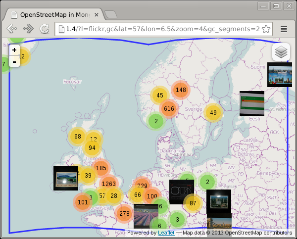
And with five intermediate points you hardly notice the problem anymore:
Play around with the gc_segments URL parameter to see for yourself:
-
http://maps.derickrethans.nl/?l=flickr,gc&zoom=5&gc_segments=1
-
http://maps.derickrethans.nl/?l=flickr,gc&zoom=5&gc_segments=2
-
http://maps.derickrethans.nl/?l=flickr,gc&zoom=5&gc_segments=3
-
http://maps.derickrethans.nl/?l=flickr,gc&zoom=5&gc_segments=10
Next up in the series is "Showing all the World's Timezones" which will explain how I created the tiles that highlight the timezones at http://maps.derickrethans.nl/?l=timezones&lon=50&lat=30&zoom=3


Life Line
Created 2 waste_baskets; Updated 2 bus_stops and 2 crossings
I hate this timeline.
For @fridaynightdinners I wanted to look up what the difference between Raviolo and Girasolo is.
DuckDuckGo's (non-ai variant) top three results are all AI generated content with AI generated author images, bio, and "flair".
I want stuff written by *humans*, not this AI slop BS.
Created 3 waste_baskets; Updated a waste_basket
Updated 6 crossings
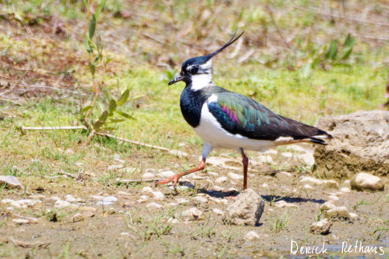
Northern Lapwing On The Move
This dapper bird is having a stroll looking for lunch. I like the iridescence in its wings.
#BirdPhotography #BirdsOfFediverse #Nature #Photography #London #BirdsOfMastodon
Created a vending_machine
Updated a bus_stop
I hiked 5.4km in 2h35m46s
I walked 2.2km in 27m13s
I walked 1.6km in 32m29s
I walked 3.3km in 34m33s
Updated a confectionery shop, a massage shop, and 2 other objects; Deleted a books shop
I hiked 7.0km in 4h21m00s
Updated a deli shop and a pet_grooming shop
I walked 4.2km in 49m42s
I walked 1.4km in 10m14s
I walked 2.2km in 1h43m13s
I walked 4.4km in 1h25m00s
Updated a cafe
Updated a bar
I walked 1.7km in 19m07s
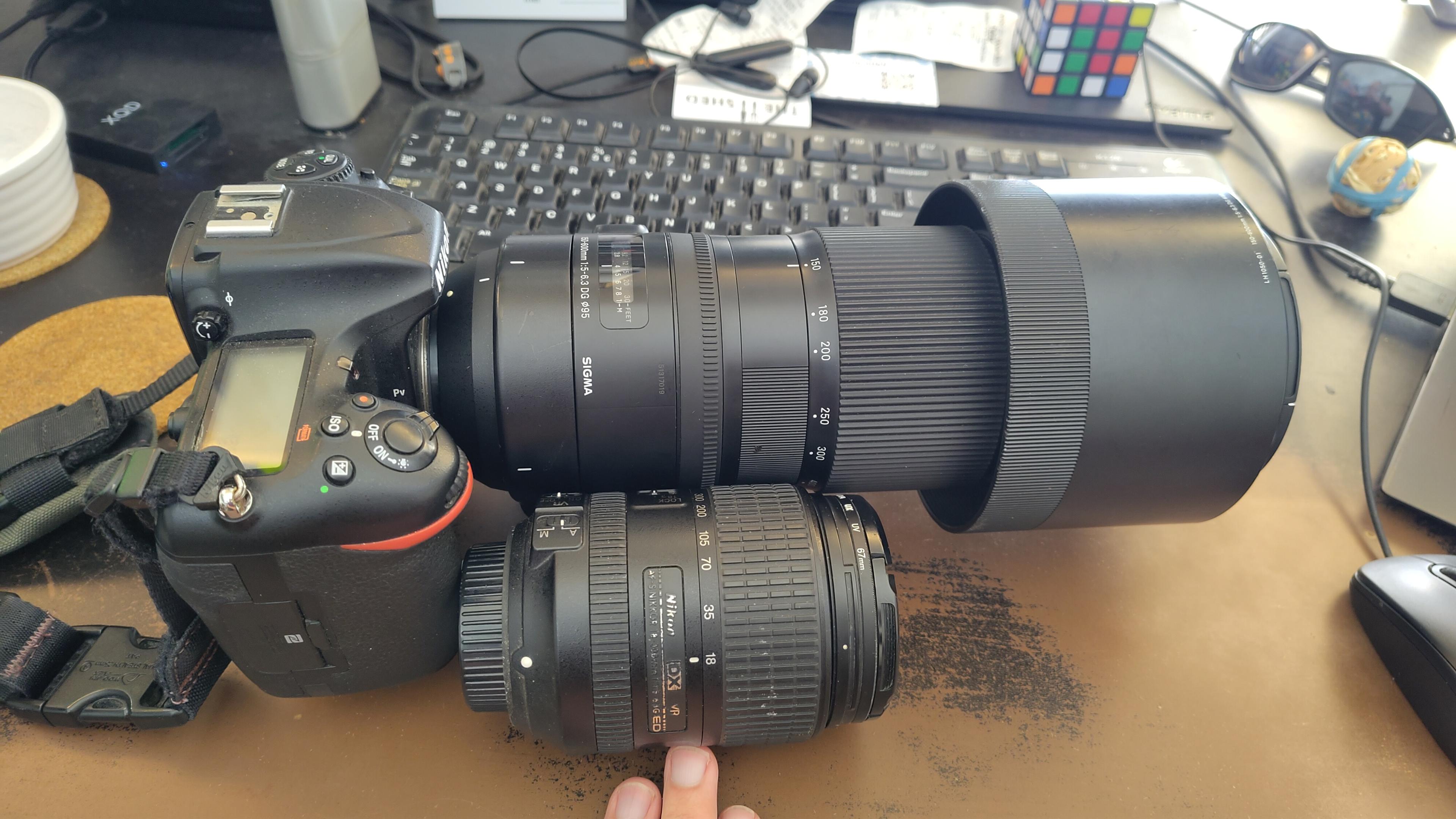
I got a new lens. It's a little bit larger, and loads heavier, than my older one.
#photography #naturephotography
I walked 1.6km in 15m10s
Shortlink
This article has a short URL available: https://drck.me/gc-a98