
Contributing Advent 10: Dragons in Dollis Hill
I had previous managed to clear out all the discrepancies on ITO World's Analysis for Camden, Kensington and Chelsea and the City of Westminster. But I have so far not yet managed to address all of the issues in my home borough Brent. I guess this is mostly because the "issues" are not really in the nicest parts of the borough—perhaps there are even dragons there. But I am trying to make a point to get to them anyway, so I set out by bus to Dollis Hill to tackle Grunwick Close, Flowers Close and St Andrews Close.
The first one, Grunwick Close was a new road and I couldn't find any street sign at all. I had to ask a local resident which indeed confirmed that I had the correct street name. The latter two actually had a "FIXME" tag on them, and no name tag. The first one, Flowers Close, was previously incorrectly mapped as Flower Road (and OS Locator had it right), but the second one was wrong on OS Locator as it had thought there was an apostrophe in "Andrews"—the street sign disagreed.
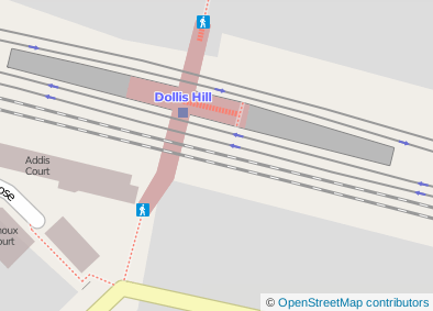
The platform at Dollis Hill had this annoyingly nagging "FIXME" tag on it and I couldn't let that go unfixed of course. (Did I mention OpenStreetMap is addictive and that I have some form of OCD?) So I spend some time mapping all the aspects of the tube station: entrances, tunnels, stairs, platforms, tracks and stop positions—all following the "new" public transport scheme. The image here shows how the new station looks like on the map.
You can see it on the website at http://www.openstreetmap.org/browse/relation/3350099


Life Line
Updated a cafe
Specify street/place names to addresses
Specify bicycle parking capacities
Specify bicycle parking fees
Specify bicycle parking access
Specify whether crosswalks have tactile paving
Specify width of opening
Specify whether pitches are lit
Specify pitch surfaces
Specify whether pedestrian crossings have markings
Specify step counts
Survey tactile paving on steps
Specify whether steps have a ramp
Specify which way leads up for steps
Specify whether pedestrian crossings have islands
Specify whether pedestrian crossings have traffic signals
Determine roads lane count
Specify whether roads have lane markings
Survey if places still exist
Specify whether roads have sidewalks
Survey postbox collection times
Survey opening hours
Determine whether ATM allows depositing cash
Specify bicycle parkings covers
Shortlink
This article has a short URL available: https://drck.me/adv1310-af2