
Contributing Advent 2: Opal Mews
Although OpenStreetMap in the United Kingdom, and specially in London, has come along very far, it is going to be nearly impossible to keep things up-to-date. We use a few external datasets to compare against to check for completion, and one of those is OS Locator. The fine folk at ITO World have created a comparison algorithm between OpenStreetMap and OS Locator, which they expose through a summary per area and a tile-layer as a visual aid.
I usually have to travel quite a bit from home to actually see a discrepancy, but since the update to the latest data set I actually found one very close to home: Opal Mews. On the site the discrepancy looked like:
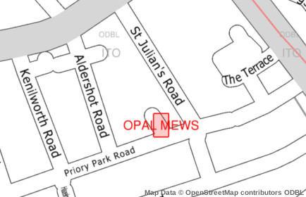
In this case, the tag is simply missing on the way. However instead of adding the data directly from OS Locator, a survey is required. In some cases, the data in OS Locator is actually wrong, even though it's supposed to be an official source. So I went past the road, checked whether the name "Opal Mews" was visible, and added the name to OpenStreetMap: http://www.openstreetmap.org/browse/changeset/19136631
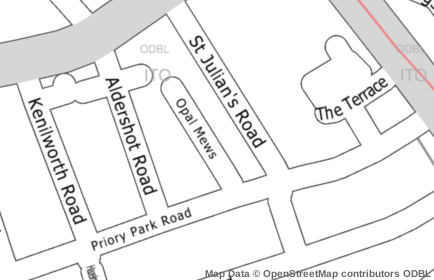
Now ITO World's OSM analysis does not have it listed as an inconsistency anymore:
One down, 18 thousand to go!

Comments
Great post! Just spotted one near my house will check it out tonight.
I think your changeset link is wrong. You added the street name in Changeset #19136631, not in #19099382.
@Edward: Thanks! I've fixed it.
Yes, it's very useful. I remember surveying one area of London because the OS Locator highlighted lots of discrepancies. It turned out that OS was wrong about most of them!
It was an area with a completely unpredictable pattern of apostrophes: "St Theobalds" vs "St Theobald's" etc. Sometimes the ground survey found an apostrophe where OS had none; sometimes the reverse. In those cases, I think you can also use the "not:name" tag to indicate that it definitely isn't what OS might think...

Life Line
Created a chocolate shop and a restaurant; Updated 6 restaurants and an address; Confirmed 5 restaurants, a community_centre, and 3 other objects
Created a restaurant, a fast_food, and 2 other objects; Deleted a restaurant
I walked 8.5km in 1h31m45s
Created 2 buildings and a hairdresser shop; Updated a restaurant and an estate_agent office; Confirmed a cafe
I walked 2.2km in 38m09s
Merged pull request #1096
Bump actions/checkout from 6 to 7
Merged pull request #1095
Improve Tiverton Green mapping
Created 2 gates
I walked 7.1km in 1h23m15s
I walked 1.0km in 9m24s
Realign streets. They now have much less wide corners into each other.
Updated a fast_food
I walked 9.1km in 1h35m41s
I hiked 4.7km in 3h24m10s
I walked 6.7km in 1h12m03s
I walked 7.7km in 1h47m24s
Updated a pub
Updated a pub
Created a bar; Updated a bar; Confirmed a restaurant and a bar
I walked 8.1km in 4h3m56s
Updated a toilet
I walked 8.8km in 2h52m21s

Shortlink
This article has a short URL available: https://drck.me/adv1302-aer